
Market Minds Advisory
Marine Survey & Geophysical Services Market

Marine Survey & Geophysical Services Market: Offshore Wind Meets Seabed Data Demand

Offshore wind developers now need seabed mapping precise enough to place turbine foundations within centimeters, but the specialized survey vessels that can deliver that resolution are booked years ahead across most fleets.

Lead Analyst

David Horsley

Published

August 2026

Make Smarter Decisions with Customized Research Insights

Request a free sample report and evaluate market opportunities, growth trends, and competitive dynamics relevant to your business needs.

2025 MARKET VALUE$6.4BMarket Size 2025
2036 FORECAST VALUE$13.6BBase Case , 2026 to 2036
CAGR 2026 TO 20367.1 %Bull 8.5% / Bear 5.8%
INCREMENTAL OPPORTUNITY$6.8BNet 10- year value creation
EXPANSION MULTIPLE1.99x2036 value over 2026 base
Strategic Levers
M&A Pipeline
Regional Outlook
Country Rankings
Competitive Intelligence
Segmental Deep-dive
Call-Us : 91 93563 13602

Executive Snapshot and Market Trajectory

Marine survey and geophysical services are being pulled away from their traditional oil and gas exploration base toward offshore wind site characterization, a shift large enough that vessel and sensor allocation, not raw demand, has become the binding constraint on project timelines.
Offshore wind site characterization grows fastest at 11.8%, roughly 1.66 times the overall rate, as developers increasingly demand seabed and geotechnical data precise enough to place turbine foundations reliably. East Asia holds the largest regional share at 28%, anchored by China's accelerating offshore wind buildout, while Western Europe follows closely on established North Sea survey capacity and expertise. That combined weight reflects genuine offshore wind and North Sea survey concentration rather than any default assumption.
Competitive intensity remains moderate, with five providers controlling roughly two-fifths of revenue, led by Fugro and TGS through decades of accumulated survey data and vessel fleet depth that regional operators struggle to replicate. Offshore wind permitting requirements are tightening across major markets, forcing providers to carry far broader geotechnical and environmental baseline capability than oil and gas surveys required. That gap keeps widening across the offshore services industry.
Market Definition
The marine survey and geophysical services market covers vessel-based and remote sensing services that map seabed topography, subsurface geology, and geotechnical conditions for offshore energy, infrastructure, and resource projects, including seismic, hydrographic, geotechnical, and environmental baseline surveys. It excludes onshore geophysical services and satellite-only remote sensing not paired with vessel or seabed-based data collection.
Base Year Value
$6.4B in 2025 (MMA Primary Research Dataset, August 2026)
Forecast Period
2026 to 2036, eleven discrete annual values
CAGR
7.1% base case. Bull 8.5%. Bear 5.8%.
Fastest Growth Segment
Offshore Wind Site Characterization Services: 11.8% CAGR
Fastest Growth Country
China: 12.6% CAGR
Fastest Growth Region
South Asia and Pacific: 8.9% CAGR
Largest Region
East Asia: 28% of 2025 global value
Market Leaders
Fugro, TGS, Shearwater GeoServices, Ocean Infinity, Sercel. Source: MMA Analysis based on company annual reports.
Primary Survey
n=3,800 procurement and R&D decision-makers, Q4 2025, six countries
Methodology
Demand-side build-up, cross-validated against public data, 47 expert interviews

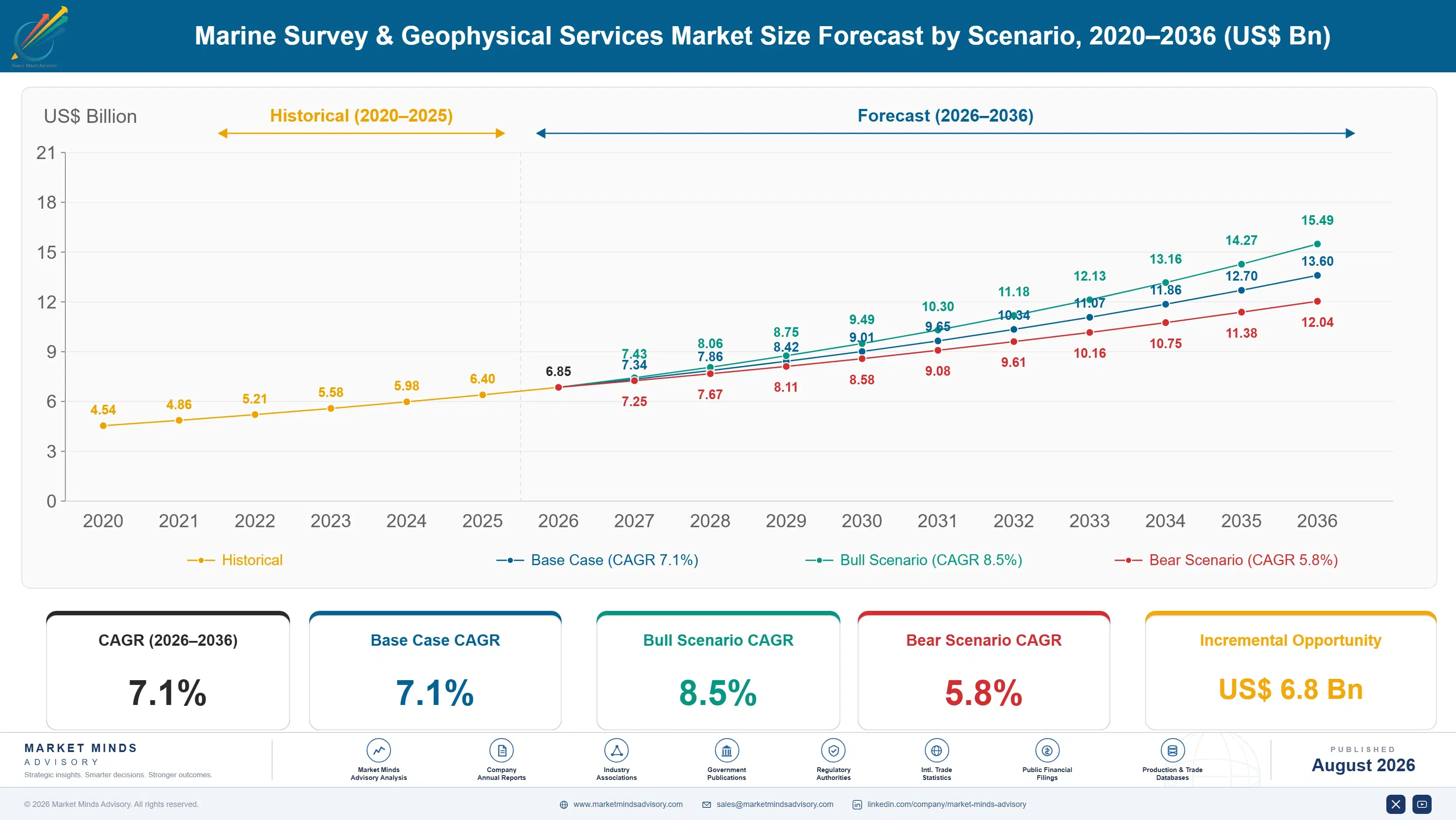
Marine Survey & Geophysical Services Market Forecast Scenarios

marine-survey-geophysical-services-market-size-forecast-scenario-1787303066797
Between 2020 and 2025 the market grew at roughly 6.2% annually, accelerating as offshore wind permitting programs across Europe and Asia converted development-stage capital directly into seabed characterization contracts across major coastal project pipelines. Rising vessel certification requirements across major coastal markets added further momentum, as developers replaced uncertified operators with documented performance suppliers meeting stricter permitting standards.
The base case carries the market to 7.1% annual growth through three mechanisms. First, offshore wind developers keep expanding geotechnical survey specification as foundation engineering requirements tighten across new project pipelines. Second, subsea cable and pipeline route surveys keep growing as interconnector and energy transmission infrastructure expands across major coastal regions. Third, autonomous survey vessel adoption keeps expanding data collection capacity, converting fleet productivity gains into a direct service delivery driver across the industry.
The bull case, 8.5%, assumes accelerating offshore wind permitting and subsea infrastructure investment pulls forward survey demand faster than currently modeled. The bear case, 5.8%, assumes offshore wind project delays and vessel day-rate inflation push budget-conscious developers back toward lower-resolution legacy survey methods instead of premium geotechnical formats across most project categories. Currency volatility across emerging offshore markets adds a further layer of uncertainty to both outcomes.

Where Seabed Data Meets Offshore Wind Buildout

Three forces converge on this market simultaneously. Offshore wind developers keep expanding geotechnical survey specification as foundation engineering requirements tighten. Subsea cable and pipeline route surveys keep growing as transmission infrastructure expands. And autonomous survey vessel adoption keeps expanding data collection capacity across the industry. Rising turbine platform scale across offshore installation programs keeps pulling integrated survey specification further into mains
MARKET CONCENTRATIONCR5: 41%Top five providers control roughly two-fifths of revenue
AVERAGE SURVEY DAY RATEUSD 25,000 to 180,000 per vesselRates vary sharply by vessel class and sensor payload
TOP COUNTRY BY REVENUEUnited Kingdom: 18% of salesEstablished North Sea survey capacity concentrates spending here
SURVEY VESSEL UTILIZATION86%Global specialized survey fleet now runs near practical maximum
VESSEL CHARTER COST SHARE44% of COGSVessel charter and fuel costs dominate service delivery expense
DATA PROCESSING TURNAROUND2 to 10 weeksSurvey complexity and client urgency determine delivery timing
Commercially, this market behaves like a specialized vessel services business layered onto project-driven permitting cycles. Providers compete on sensor precision and vessel fleet availability as much as on price, since offshore wind developers increasingly demand documented survey accuracy before committing to a foundation design. That fleet depth increasingly separates leading providers from regional survey operators. Buyers treat validated accuracy documentation as a prerequisite before shortlisting a provider.
Over the next decade expect continued expansion beyond oil and gas exploration into offshore wind and subsea infrastructure formats. China's offshore wind buildout will keep anchoring global demand growth. And autonomous vessel fleet depth, more than raw survey capacity alone, will increasingly determine which providers developers actually specify into new project pipelines. Fleet depth increasingly separates durable developer relationships from one-time commodity vessel charters across every application category tracked.
"Nobody notices a seabed survey until a foundation fails to seat properly. By then the vessel that could have caught it has already moved on to the next contract."
Director, Offshore Energy Services Practice · MMA Energy Practice ·

Market Trends

Offshore Wind Developers Demand Precision Geotechnical Data

Offshore wind developers increasingly specify geotechnical surveys precise enough to characterize seabed conditions at each individual turbine foundation location, a requirement that has converted survey specification from a general site assessment into a core engineering design input. This shift addresses a genuine engineering constraint, since foundation design increasingly depends on granular soil and seabed data that legacy regional surveys cannot always deliver at the resolution modern turbine scale requires. Several providers have expanded dedicated geotechnical survey fleets engineered specifically for offshore wind foundation characterization, positioning this format as the category's clearest growth driver.
Market Impact: Anchors 28% of global survey demand
Autonomous Survey Vessels Expand Data Collection Capacity

Survey providers increasingly deploy autonomous and remotely operated survey vessels to expand data collection capacity without proportionally expanding crewed vessel fleets, converting fleet productivity into a direct competitive differentiator rather than a general cost reduction measure. This shift addresses a genuine capacity constraint, since crewed survey vessels remain in persistently short supply relative to accelerating offshore wind and subsea infrastructure demand. Several providers have expanded autonomous vessel fleets capable of extended, lower-cost data collection missions, positioning fleet automation as a durable differentiator across the offshore services industry. Client demand for continuous survey coverage keeps rising across major offshore basins.
Market Impact: Adds 28% share via offshore demand

Market Opportunities and Growth Drivers

Global Offshore Wind Permitting Pipelines Keep Expanding

Offshore wind developers worldwide keep expanding permitting and pre-construction survey programs as both fixed-bottom and floating project pipelines scale, converting renewable energy capital budgets directly into geophysical and geotechnical survey demand independent of the broader oil and gas exploration cycle affecting other service segments. This creates durable demand that spans nearly every major coastal market simultaneously, since permitting requirements extend years before any single project reaches construction. Providers increasingly design survey programs specifically for offshore wind foundation and cable route requirements, converting what was once an oil and gas specialty service into a standard requirement across the renewable energy sector.
Market Impact: Adds lead times exceeding 18 months

China's Offshore Wind Buildout Scales Survey Demand

China's continued investment in offshore wind capacity keeps converting public and private capital budgets directly into seabed and geotechnical survey demand, independent of the broader onshore renewable cycle affecting other segments of the country's energy market. This creates demand that spans nearly every major Chinese coastal province simultaneously, since offshore wind project pipelines extend years beyond any single budget cycle. Domestic Chinese providers increasingly supply survey capability that previously relied on imported Western vessel technology, converting what was once an imported specialty service into a locally delivered infrastructure standard. Provincial developers increasingly specify domestic survey capability directly in tender documents.
Market Impact: Adds cost swings exceeding 24% annu

Market Restraints and Challenges

Specialized Survey Vessel Shortage Limits Growth

Building new specialized survey vessels requires years of capital investment and shipyard capacity that competes directly with broader commercial shipbuilding demand, a limitation that leaves providers unable to expand fleet capacity as quickly as accelerating offshore wind demand requires. The root cause is industrial: specialized survey vessel construction requires purpose-built sensor integration and shipyard expertise that few yards possess at scale. The impact falls hardest on smaller developers, since they lack the contract volume to secure guaranteed vessel allocation that larger developers negotiate directly with providers. Some providers are responding by expanding dedicated newbuild survey vessel programs.
Market Impact: Cuts foundation risk by 30%

Vessel Charter Cost Volatility Pressures Margins

Vessel charter and fuel costs swing considerably with broader maritime commodity cycles, since survey providers compete for vessel capacity with offshore construction and shipping industries drawing on the same charter market, a volatility that providers cannot always pass through to price-sensitive developers on fixed-budget permitting contracts. The root cause is genuinely industrial: charter pricing tracks global maritime supply and demand cycles that survey providers do not control directly. The impact falls hardest on smaller regional providers lacking long-term charter agreements. Some providers are responding by securing dedicated multi-year vessel charter contracts.
Market Impact: Adds vessel capacity across 32%
3 additional market trends, 3 additional growth drivers, and 4 additional restraints and challenges are covered in the full report. Contact sales@marketmindsadvisory.com to access the complete intelligence.

Segment CAGR and Growth Architecture

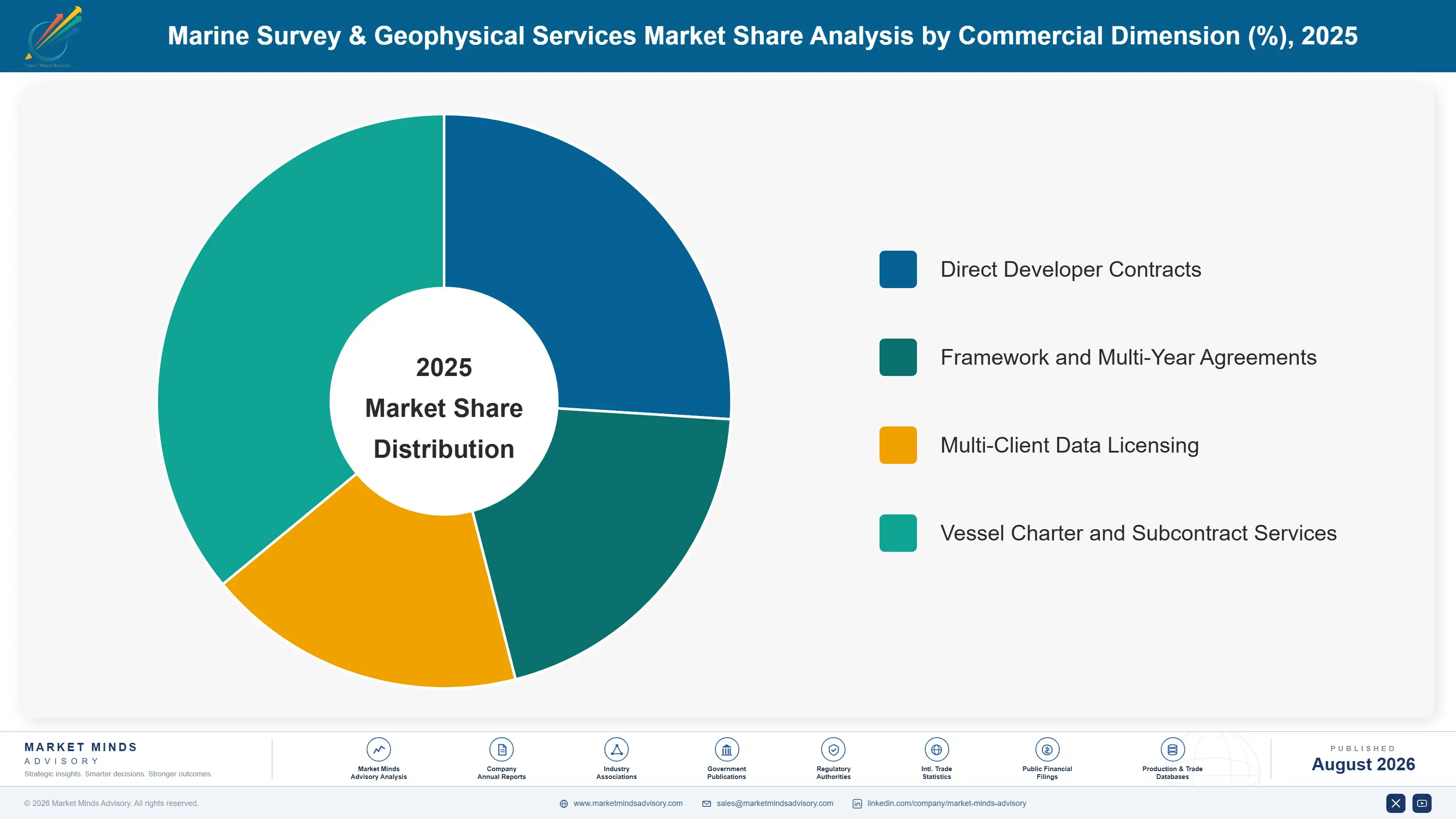
Segmentation follows service type, the single classification logic that determines survey method, sensor payload, and vessel requirement. Seismic, hydrographic, geotechnical, environmental baseline, and site characterization services each carry distinct technical requirements, so commercial position tracks service type rather than end-use application across every provider profiled in this review. Buyers evaluate providers through this service lens rather than end-use category.
marine-survey-geophysical-services-market-market-share-analysis-1787303067406

Offshore Wind Site Characterization Services

Offshore wind site characterization grows fastest at 11.8%, roughly 1.66 times the overall market rate, as developers increasingly demand integrated geophysical and geotechnical data packages that legacy single-discipline surveys cannot deliver within permitting timelines. This service's combination of seabed mapping, soil characterization, and environmental baseline data makes it the preferred choice for foundation design across both fixed-bottom and floating turbine platforms. Fugro and TGS lead this segment's integrated survey development, while Ocean Infinity and Shearwater compete on autonomous vessel deployment speed. Growing global offshore wind permitting activity continues expanding this segment's addressable base considerably beyond its original North Sea origins. Developer framework agreements continue strengthening this segment's contract reliability across major markets.
CAGR 11.8%

Geotechnical Survey Services

Geotechnical surveys grow second-fastest at 9.4%, about 1.32 times the overall rate, as both offshore wind and subsea infrastructure projects increasingly demand detailed soil sampling and in-situ testing data that seismic surveys alone cannot provide. This service's direct sampling and cone penetration testing capability makes it the preferred choice for foundation design validation across diverse seabed conditions. Fugro and Gardline lead this segment's sampling technology development, while regional providers compete on vessel availability and turnaround speed. Growing subsea infrastructure investment continues expanding this segment's addressable base considerably beyond its original oil and gas origins. Expanding subsea cable route surveys across secondary markets continue reinforcing this segment's steady volume growth over time.
CAGR 9.4%
Full segment breakdown across 5 segments available in the complete report.

Regional Architecture and Country Demand Map

East Asia leads at 28% of the total, anchored by China's accelerating offshore wind buildout. Western Europe follows closely on established North Sea survey capacity. North America holds a share tied to Gulf of Mexico and Atlantic wind demand, while the remaining four regions complete global distribution.

North America

The United States and Canada anchor North America's 23% share through expanding Atlantic coast offshore wind permitting and sustained Gulf of Mexico oil and gas survey demand operating side by side across the region. The United States hosts the region's deepest survey vessel charter infrastructure, with Fugro and TGS's American operations serving both offshore wind and oil and gas channels simultaneously. Canada's comparable Atlantic survey demand adds incremental volume beyond American consumption specifically. Growth of 7.4% reflects steady offshore wind and oil and gas demand more than any single regulatory deadline alone. Certification density across this region's permitting channel keeps its premium service mix wider than most others tracked. Certification density keeps this region's premium mix wider.
Share: 23% | CAGR: 7.4% (2026 to 2036)

Western Europe

The United Kingdom, Germany, and the Netherlands anchor Western Europe's 26% share through the world's most established North Sea survey industry, built on decades of oil and gas exploration expertise now redirected toward offshore wind site characterization. Fugro and Shearwater's core European operations serve both domestic offshore wind and export markets across the continent. Nordic markets contribute meaningful floating wind survey demand beyond the core UK and German base. Growth of 6.0%, the softest pace among the seven regions tracked, reflects this underlying market maturity rather than weakening underlying offshore wind or oil and gas demand overall. Regulatory harmonization across member states keeps compliance requirements comparatively predictable for providers selling continentally.
Share: 26% | CAGR: 6.0% (2026 to 2036)
Regional intelligence for 5 additional markets available in the complete report: East Asia, South Asia and Pacific, Latin America, Middle East and Africa, Eastern Europe. Contact sales@marketmindsadvisory.com.
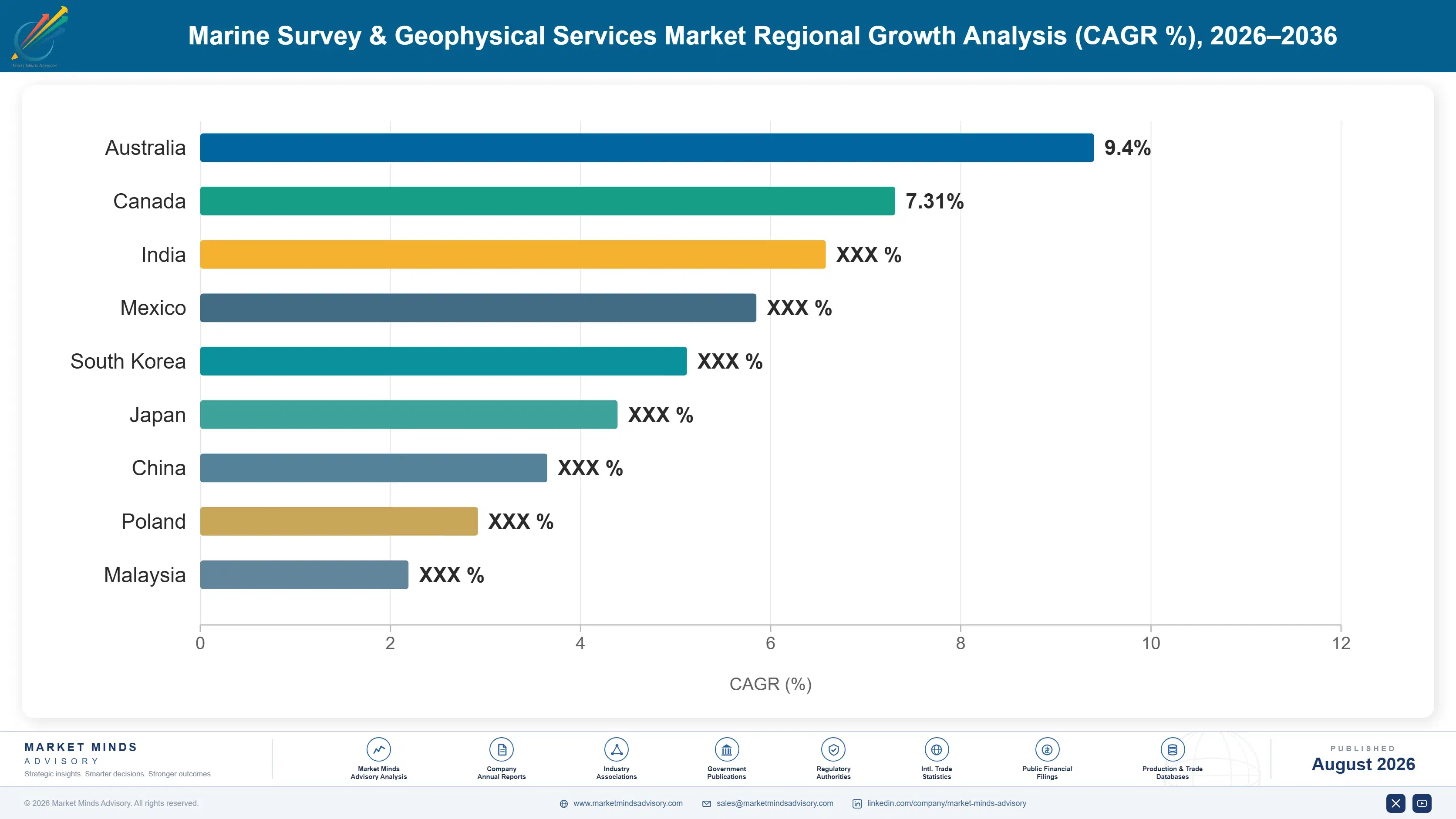
marine-survey-geophysical-services-market-country-cagr-analysis-1787303068013

How Providers Can Defend Survey Margin

Margin increasingly depends on autonomous vessel fleet depth and documented survey accuracy rather than raw charter rates alone, as developers demand dependable data delivery alongside permitting-cycle reliability. The four levers below target fleet, service, and financing revenue that marine survey providers have left underexploited, converting a commodity vessel charter into a longer, more defensible developer relationship.

Guarantee Multi-Year Vessel Allocation Well Early

Providers increasingly offer guaranteed multi-year vessel allocation commitments to strategic offshore wind developers, capturing specification loyalty that providers without allocation guarantees leave on the table since developers require guaranteed vessel availability for multi-phase permitting and construction planning amid genuine vessel supply constraints. Fugro and TGS both report that allocation commitments directly determine which developer contracts they can even secure, independent of day-rate pricing. Building this capability requires investment exceeding $5 million per newbuild vessel program, but providers who commit early lock in developer relationships before competitors can match the commitment depth.
Market Impact: Wins developer contracts each worth

Offer Extended Data Accuracy Guarantee Coverage

Providers increasingly offer extended data accuracy guarantees that back documented survey precision beyond the standard service agreement, capturing premium pricing that providers without accuracy guarantees leave on the table since risk-averse developers pay meaningfully more for documented precision assurance. Buyers pay 12% to 20% more for surveys backed by extended accuracy guarantees than for equivalent services without guaranteed precision, since guarantee-backed data directly reduces the developer's foundation engineering risk exposure. This reputation compounds into durable specification advantage over time across major projects. Buyers treat guarantee depth as a proxy for underlying survey quality when comparing bids.
Market Impact: Commands 12% to 20% higher day rate

Bundle Environmental Permitting Support Services Directly

Providers increasingly bundle environmental baseline data collection and permitting documentation support with survey contracts, capturing service revenue that providers without support services leave on the table since smaller developers often lack in-house regulatory expertise for complex offshore wind environmental impact assessments. This service model captures 9% to 15% incremental revenue beyond commodity survey pricing, since developers increasingly value providers who can accelerate their own permitting timeline rather than suppliers who simply deliver data without ongoing support. Building this capability requires investment in regulatory affairs staff, and the margin differential justifies it.
Market Impact: Generates 9% to 15% recurring annua

Expand Autonomous Vessel Fleets Near Demand Hubs

Charter cost and vessel mobilization time from distant fleets have risen enough that regional autonomous vessel basing, closer to major offshore wind permitting hubs, increasingly beats centralized fleet economics even at somewhat higher local basing cost. Providers building autonomous vessel bases in China, the United Kingdom, and the United States, rather than relying entirely on centralized fleet deployment, cut mobilization cost by roughly 17% while also shortening lead times that matter increasingly to fast-track permitting schedules. This shift requires upfront capital investment, but providers who move early capture share from centralized competitors.
Market Impact: Cuts mobilization costs by roughly

Who Controls the Margin Pool

Five providers control roughly two-fifths of global revenue, a moderately fragmented picture for a specialized vessel services category served by numerous regional operators alongside global fleet owners. Fugro and TGS lead on scale, though Fugro leads geotechnical and integrated survey breadth while TGS leads seismic data licensing depth. Revenue, the basis used throughout this assessment, favors providers with the broadest vessel fleet and sensor capability.
Competitive activity runs across three dimensions. Providers race to expand autonomous vessel fleets before rivals lock in long-term developer framework agreements. Data accuracy guarantees and permitting support offerings have become a differentiator, as risk-averse developers increasingly prefer providers who can document guaranteed precision. Chinese domestic providers are winning standard-range offshore wind survey deals that once belonged primarily to established Western suppliers.

Pressure is building from two directions that could reshuffle rankings within the decade. Chinese and other regional providers, still largely absent from the global key player list, are scaling autonomous vessel fleets to serve domestic offshore wind growth closer to demand. Specialized floating wind and deepwater survey makers, outside the established fixed-bottom franchise, are proving emerging-format depth can command pricing conventional providers struggle to match, forcing established players toward deeper autonomous fleet investment.
marine-survey-geophysical-services-market-company-positioning-matrix-1787303068615

Competitive Moat and Risk Dimensions

FUGRO N.V.

Moat: Broadest Integrated Survey Depth

Fugro holds one of the broadest integrated geophysical and geotechnical survey networks of any provider, spanning nearly every major offshore wind and oil and gas market built on decades of accumulated seabed and soil characterization data. That breadth lets it bid on multi-discipline developer contracts that narrower regional specialists cannot match on documented reliability depth alone.
FUGRO N.V.

Risk: Premium Pricing Limits Budget Reach

Fugro's premium engineering-driven positioning leaves it less price-competitive in budget-conscious standard-range applications where Chinese and regional providers increasingly capture volume that Fugro's cost structure cannot profitably match without meaningfully compromising the brand's premium performance-driven positioning elsewhere. That gap could widen as regional providers keep scaling technical capability.
TGS ASA

Moat: Deep Seismic Data Licensing Library

TGS holds a particularly deep multi-client seismic data licensing library, built on decades of survey investment that lets it monetize existing datasets repeatedly across multiple developer customers without redeploying vessels for each new project. That data reuse converts directly into stronger margins than single-contract survey delivery alone.
TGS ASA

Risk: Narrower Geotechnical Service Depth

TGS's core strength in seismic data licensing leaves it less positioned to capture the fastest-growing offshore wind geotechnical survey segment compared with competitors who built dedicated soil sampling capability earlier in the category's development. This gap could narrow the company's addressable volume over time. This gap could widen further as offshore wind overtakes seismic exploration in overall market weight.

Players Tracked

Prominent Players

Fugro N.V.
TGS ASA
Shearwater GeoServices Holding AS
Ocean Infinity Group Limited
Sercel

Other Key Players

Gardline Limited
SGS SA
Bureau Veritas SA
RPS Group Limited
COWI A/S
Osiris Projects Ltd.
Reach Subsea ASA
N-Sea Group B.V.
Deep Ocean Group Holding AS
Boskalis Offshore Energy
China Oilfield Services Limited (COSL)
PGS ASA
SBG Marine Group
Seafloor Systems, Inc.
Kraken Robotics Inc.

Recent Developments

JANUARY 2025

Fugro Expands Geotechnical Survey Vessel Fleet In The United Kingdom

Fugro expanded its geotechnical survey vessel fleet at an existing British operating base, aiming to meet growing demand from offshore wind developers. The expansion added meaningful annual survey capacity without requiring an entirely new vessel construction program, ahead of the anticipated demand cycle. Full capacity follows within months.
Signal: Signals established global providers are p
MAY 2025

TGS Signs Framework Agreement With A Chinese Offshore Wind Developer

TGS signed a multi-year framework agreement with a major Chinese offshore wind developer to provide site characterization surveys across several new project sites. The agreement was structured as a direct service contract rather than any joint venture or equity arrangement, ahead of a planned construction ramp.
Signal: Signals established providers are securing
SEPTEMBER 2025

Ocean Infinity Acquires A Regional Autonomous Vessel Specialist

Ocean Infinity completed the acquisition of a regional autonomous survey vessel specialist, adding fleet capability to its existing survey portfolio. The transaction was a full acquisition, not a licensing or minority equity investment arrangement. The specialist brought vessel technology Ocean Infinity previously lacked internally. Integration completes within the coming year.
Signal: Signals established providers are consolid

What Actually Drives Marine Survey Cost

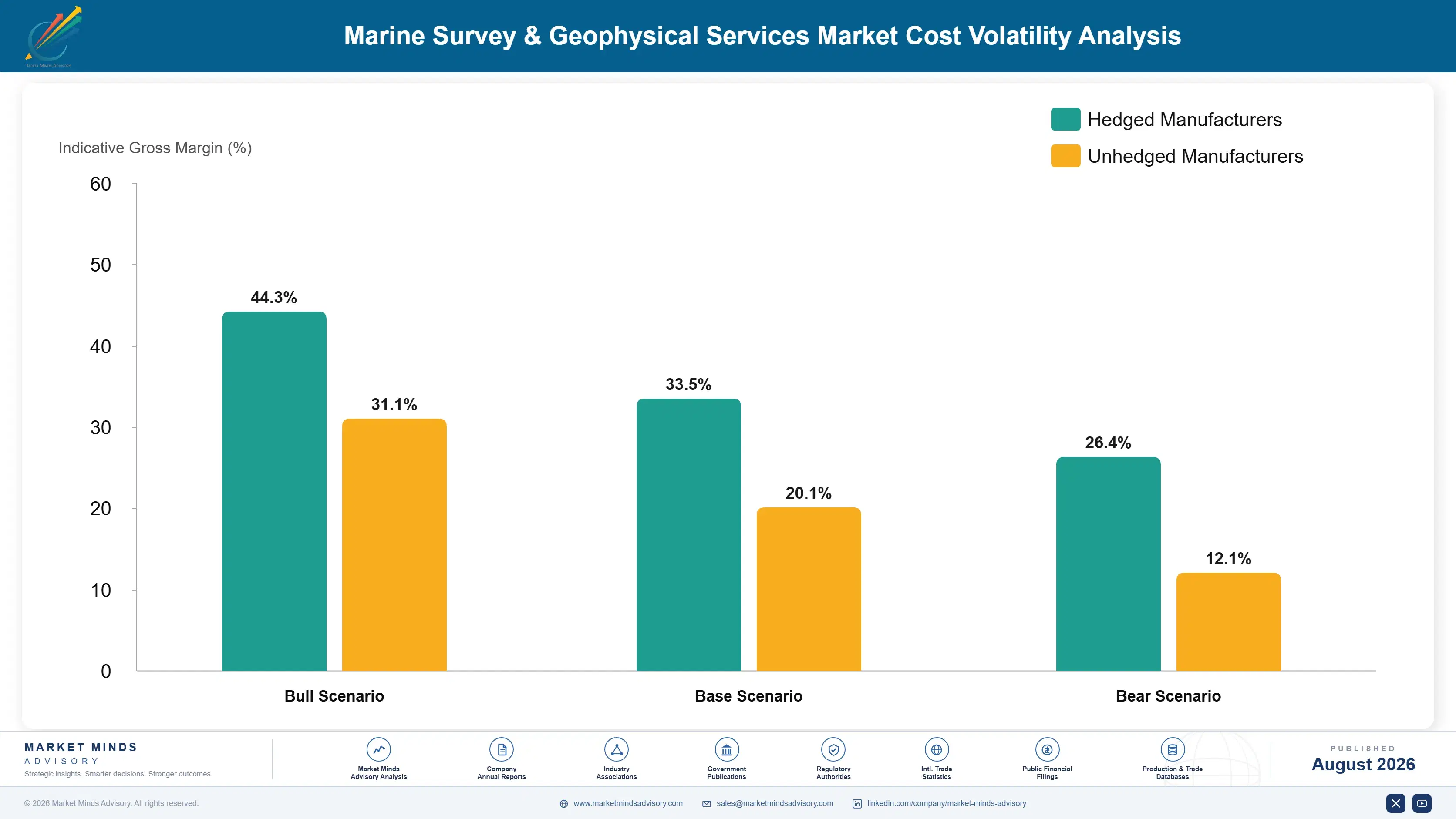
Vessel charter and marine fuel costs account for roughly 44% of service delivery cost, sourced from charter markets and bunker fuel suppliers concentrated in the North Sea, Gulf of Mexico, and Southeast Asian shipping hubs. Sensor equipment and data processing costs add another 22%, while crew and logistics costs make up most of the remainder across provider operations. Vessel charter remains the single largest cost driver.
Marine fuel and vessel charter rates spiked in 2021 and 2022 as broader energy commodity inflation raised bunker fuel cost shared with shipping and offshore construction industries competing for the same vessel capacity. Fugro's 2022 annual report cited elevated charter and fuel costs as a direct pressure on survey margins that year, and several providers reported similar pressure, pushing some smaller operators toward temporary fleet reductions until commodity pricing eased into 2023 and 2024.

Smaller regional operators carry the sharpest exposure, since they lack the contract volume to negotiate long-term charter agreements that Fugro and TGS secure directly with vessel owners. Geographic exposure varies too: providers with owned fleets face lower cost volatility than those dependent on spot-chartered vessels, a gap that widens whenever global charter rates spike against relatively stable owned-fleet operating costs.
marine-survey-geophysical-services-market-cost-volatility-analysis-1787303068823

Lock Multi-Year Vessel Charter Agreements

Providers with sufficient contract volume are negotiating multi-year vessel charter agreements directly with vessel owners, trading pricing flexibility for guaranteed allocation during industry-wide charter shortages. This approach favors the largest providers, since minimum volume commitments required for favorable terms sit beyond what smaller regional operators can commit to. Smaller operators lack this negotiating leverage.

Expand Owned Autonomous Vessel Fleets

Some providers now expand owned autonomous vessel fleets that reduce spot charter dependency across multiple survey programs rather than relying entirely on chartered crewed vessels, trading upfront capital investment for meaningfully improved cost predictability during recurring charter shortages. Larger providers with diverse fleet portfolios pursue this path most successfully across cycles. This tradeoff grows more attractive as shortages recur.

Build Regional Vessel Bases Near Demand

Basing vessels closer to major offshore wind permitting hubs, as several providers have done in China and the United Kingdom, cuts mobilization cost and currency exposure even when core fuel and equipment still ship from concentrated global suppliers. This shift requires meaningful capital investment but pays off steadily for regionally based providers over time.

Portfolio Architecture for Margin Defence

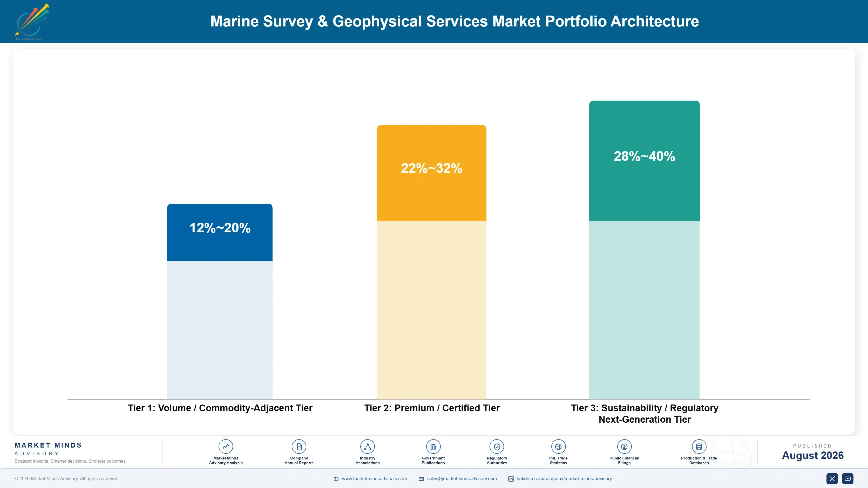
The portfolio splits into three tiers with clear margin separation. Volume-tier services, standard hydrographic surveys sold largely on day rate into commodity infrastructure channels, compete hard and earn modestly. Premium certified services, covering geotechnical and integrated site characterization formats meeting documented accuracy specifications, earn considerably more because sensor and vessel depth support pricing. Next-generation autonomous and floating wind survey solutions occupy the
The tension here is common to specialized vessel businesses: volume hydrographic revenue funds the fleet scale premium services depend on, yet volume growth alone cannot fund the autonomous vessel research and floating wind development investment next-generation solutions require. Providers leaning too heavily into premium positioning risk losing the fleet scale that makes market entry viable in price-sensitive infrastructure channels, while volume players cede premium offshore wind specification to diversified rivals.

High-value pools concentrate where autonomous fleet innovation, data accuracy depth, and permitting reliability intersect: integrated offshore wind site characterization services serving developers willing to pay for verified, documented precision. That intersection is a minority of revenue globally but expanding quickly, which is why the next-generation tier grows fastest even while representing a modest volume share.

Volume / Commodity-Adjacent Tier

Standard hydrographic and shallow-water surveys sold largely on day rate into commodity infrastructure channels, competing directly against low-cost regional operators across most price-sensitive markets. Margins here compress steadily each year.
Gross Margin: 12%-20%

Premium / Certified Tier

Geotechnical and integrated site characterization formats meeting documented accuracy specifications, sold to developers willing to pay for sensor depth and proven reliability. This tier increasingly anchors long-term framework relationships and repeat contracts.
Gross Margin: 22%-32%

Sustainability / Regulatory / Next-Generation Tier

Autonomous and floating wind survey solutions representing the fleet innovation frontier, priced at a premium justified by engineering depth and expanding offshore wind application scope. Few providers currently compete here, leaving room for early leadership.
Gross Margin: 28%-40%
marine-survey-geophysical-services-market-portfolio-architecture-1787303069401

How Survey Demand Actually Commits

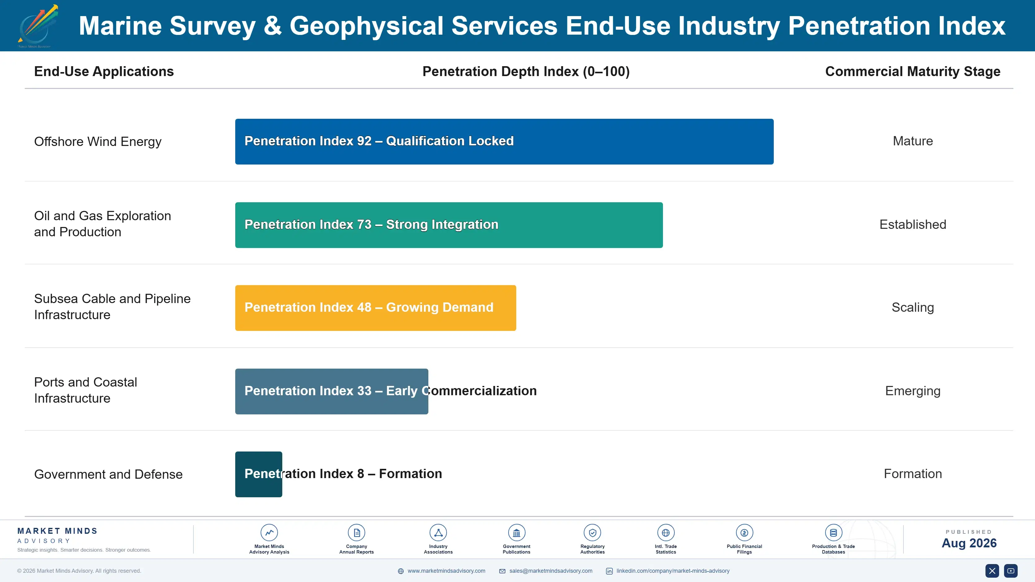
Demand here commits through a long permitting and engineering cycle rather than a point-of-sale decision. A developer that qualifies a provider for site characterization typically commits to that provider for the entire permitting and construction run, since switching mid-project would require re-mobilizing vessels and re-validating survey data already submitted to regulators. That long-commitment structure makes this market behave like a program-based annuity once a provider secures a developer
Adoption depth varies by application category. Offshore wind developers adopt integrated survey formats readily, given the permitting and foundation engineering demands that make documented accuracy essential rather than optional. Standard infrastructure buyers adopt more cost-consciously, weighing data quality against a purchase price that competes with tighter project budgets. Oil and gas operators occupy a distinct position, often prioritizing legacy provider relationships over marginal cost differences between comparable services.

Younger project engineers increasingly research vessel fleet capability and accuracy documentation directly rather than relying entirely on provider sales representatives that previous engineering generations depended on for procurement guidance. That shift is pushing providers toward more transparent published fleet data and digital survey planning tools, even though long-term framework relationships remain the actual purchasing mechanism for most developer and infrastructure accounts today.
marine-survey-geophysical-services-market-end-use-penetration-index-1787303069924

Where This Market Rewards Fleet Depth

These are among the four positions where our research anticipates prominent divergence between winners and laggards over the coming forecast period. Each is grounded in the demand model, the regulatory perimeter, and the announced capacity pipeline.
01 / AUTONOMOUS FLEET STRATEGY

Winners will expand autonomous capacity before rivals

Raw survey chemistry alone no longer separates leading providers, since most competitors can eventually match a given data accuracy specification within a few project cycles. What actually separates winners is the depth of autonomous vessel capacity available to strategic developer customers, because a technically capable survey design without reliable vessel availability cannot win the specification decisions that increasingly require production certainty before permitting closes. Providers building dedicated autonomous fleet capability, rather than treating it as an afterthought, will out-earn technically comparable rivals over the coming decade.
02 / REGIONAL VESSEL BASING FOOTPRINT

Local vessel basing will decide Asian market access

Mobilization cost and delivery lead time, not raw survey cost alone, increasingly determine which providers can compete profitably as China and other Asian markets scale their own offshore wind base rapidly. Providers who build regional vessel bases early will capture access that purely centralized competitors cannot match, regardless of how competitive their underlying day-rate pricing might otherwise be under normal market conditions. Those relying entirely on distant centralized fleets will find themselves increasingly unable to serve the fastest-growing Asian markets within this decade.
03 / SERVICE AND PERMITTING REVENUE

Permitting support will matter more than bulk surveys

Providers still competing purely on bulk day-rate price are leaving durable revenue on the table that permitting support and extended accuracy guarantee services already capture successfully for service-forward competitors across major markets. These recurring revenue streams persist independent of the lumpy program permitting cycles that otherwise define this market's uneven revenue pattern tied to offshore wind build schedules. Companies that build genuine permitting and guarantee capability early will earn materially more per developer relationship over a decade than those still selling only vessel time.
04 / OFFSHORE WIND SURVEY INVESTMENT

Integrated survey engineering will matter more than legacy volume

Even where established oil and gas demand keeps growing steadily, long-term margin growth is increasingly shaped by how quickly providers secure integrated offshore wind specification across the fastest-growing floating and fixed-bottom platforms, a transition individual providers cannot simply accelerate through marketing alone. Providers who invest early in autonomous fleet research and offshore wind-specific engineering will capture positioning ahead of competitors still dependent entirely on legacy oil and gas demand. This constraint will matter more to realized long-term margin than any single near-term pricing decision alone across every application category tracked.

Engagement Snapshot From the Field

A live engagement with an industry participant carrying material or product regulatory and market exposure ahead of a defining policy shift, showing how our research translates into a defensible multi-year portfolio strategy.
MARKET MINDS ADVISORY · CLIENT ENGAGEMENT SUMMARY
Marine Survey & Geophysical Services Producer Strategic Portfolio Review and Transition Roadmap 2026·Investment Scenario on Marine Survey & Geophysical Services Exposure Evaluation 2025-26
CLIENT PROFILE
A regional marine survey operator approached MMA while evaluating whether to expand its hydrographic fleet into offshore wind geotechnical capacity or continue focusing exclusively on its established infrastructure survey strength. The operator reported annual revenue near USD 39 million, with roughly 72% derived from hydrographic and shallow-water surveys sold into port and infrastructure channels (client-reported, unverified by MMA).
STRATEGIC CHALLENGE
Leadership believed geotechnical expansion would meaningfully capture growing offshore wind demand, but nobody had modeled the additional vessel investment and crew certification timeline against the potential competitive advantage, nor assessed which sensor package would best balance capability against the operator's existing fleet financing structure. This uncertainty delayed the fleet investment decision by several months.
MMA APPROACH
MMA benchmarked geotechnical vessel configurations across four competitor providers against the client's existing fleet capability, modeled vessel investment and certification timeline scenarios against comparable prior fleet expansions, and interviewed procurement managers at three regional offshore wind developers on real-world preference between chartered and owned geotechnical capacity and reviewed comparable published utilization data.
KEY FINDINGS
  1. A phased vessel retrofit plan building on the operator's existing hull inventory offered the clearest path to market entry, based on comparable competitor fleet timelines (client-reported, unverified by MMA).
  2. Developer interviews revealed stronger contract interest in geotechnical capacity than the operator's own market research had previously indicated. This gap influenced the final fleet investment decision materially.
  3. The retrofit timeline for geotechnical entry ran only modestly longer than the operator's standard vessel maintenance cycle, given shared shipyard relationships. Shared shipyard slots cut the projected capital investment meaningfully.
  4. Two of the four competitor providers evaluated had secured meaningfully stronger developer framework agreements after expanding geotechnical capacity than hydrographic-only comparable peers.
CLIENT PROFILE
A regional marine survey operator approached MMA while evaluating whether to expand its hydrographic fleet into offshore wind geotechnical capacity or continue focusing exclusively on its established infrastructure survey strength. The operator reported annual revenue near USD 39 million, with roughly 72% derived from hydrographic and shallow-water surveys sold into port and infrastructure channels (client-reported, unverified by MMA).
STRATEGIC CHALLENGE
Leadership believed geotechnical expansion would meaningfully capture growing offshore wind demand, but nobody had modeled the additional vessel investment and crew certification timeline against the potential competitive advantage, nor assessed which sensor package would best balance capability against the operator's existing fleet financing structure. This uncertainty delayed the fleet investment decision by several months.
MMA APPROACH
MMA benchmarked geotechnical vessel configurations across four competitor providers against the client's existing fleet capability, modeled vessel investment and certification timeline scenarios against comparable prior fleet expansions, and interviewed procurement managers at three regional offshore wind developers on real-world preference between chartered and owned geotechnical capacity and reviewed comparable published utilization data.
KEY FINDINGS
  1. A phased vessel retrofit plan building on the operator's existing hull inventory offered the clearest path to market entry, based on comparable competitor fleet timelines (client-reported, unverified by MMA).
  2. Developer interviews revealed stronger contract interest in geotechnical capacity than the operator's own market research had previously indicated. This gap influenced the final fleet investment decision materially.
  3. The retrofit timeline for geotechnical entry ran only modestly longer than the operator's standard vessel maintenance cycle, given shared shipyard relationships. Shared shipyard slots cut the projected capital investment meaningfully.
  4. Two of the four competitor providers evaluated had secured meaningfully stronger developer framework agreements after expanding geotechnical capacity than hydrographic-only comparable peers.
RECOMMENDED STRATEGY
Phase 1: Phase 1 (0 to 6 months): Finalize the phased vessel retrofit plan and begin sensor integration testing directly with equipment suppliers. Phase 2: Phase 2 (6 to 15 months): Complete crew certification and vessel commissioning while maintaining the existing hydrographic survey fleet and customer relationships. Phase 3: Phase 3 (15 to 24 months): Launch geotechnical survey availability to regional offshore wind developers, monitoring early contract wins and utilization data.
OUTCOME
The operator proceeded with the phased vessel retrofit plan and began sensor integration on schedule, tracking meaningfully faster than the originally projected timeline, with commissioning completed ahead of the internal target date. The operator reported strong early developer interest ahead of the anticipated service launch (client-reported, unverified by MMA).

Frequently Asked Questions

Foundational context covering the market sizes, CAGR, scope, country, region and competition that inform every finding below. This section is provided to cover basics and most often pre-purchase conversations, answered from the MMA Primary Research Dataset.

What is the current size of the Marine Survey & Geophysical Services Market?

The market stood at USD 6.4 billion in 2025, based on MMA Primary Research Dataset findings. Offshore wind permitting demand remains the fastest-growing driver of specification volume.

How large will the Marine Survey & Geophysical Services Market be by 2036?

MMA projects the market will reach USD 13.60 billion by 2036 under the base case scenario, representing roughly 1.99 times the 2026 opening value across the eleven-year forecast period.

What is the CAGR for the Marine Survey & Geophysical Services Market 2026 to 2036?

The base case CAGR is 7.1% annually. MMA's bull scenario reaches 8.5% while the bear scenario, reflecting vessel supply constraints, runs closer to 5.8% over the period.

Which segment is growing fastest?

Offshore wind site characterization services lead at 11.8% CAGR, roughly 1.66 times the overall market rate, as developers demand integrated seabed data at scale. This positions the segment well ahead of every other service format tracked.

Who are the major companies in the Marine Survey & Geophysical Services Market?

Fugro, TGS, Shearwater GeoServices, Ocean Infinity, and Sercel lead the market, together controlling an estimated 41% of global revenue on a consistent basis measured across every service category.

Which country is growing fastest?

China posts the fastest national growth at 12.6% CAGR, driven by its accelerating offshore wind buildout and expanding domestic vessel fleet. Domestic providers increasingly compete for regional export contracts.

Report Segmentation Architecture

The full report scope spans multiple orthogonal segmentation dimensions, with cross-tabulated demand data provided for each dimension pair. Coverage extends further to regional breakdowns, trend trajectories, and the competitive detail needed to support segment-level decision-making.

By Service Type

  • Seismic Survey Services
  • Hydrographic Survey Services
  • Geotechnical Survey Services
  • Environmental Baseline Survey Services
  • Offshore Wind Site Characterization Services

By End-Use Industry

  • Offshore Wind Energy
  • Oil and Gas Exploration and Production
  • Subsea Cable and Pipeline Infrastructure
  • Ports and Coastal Infrastructure
  • Government and Defense

By Commercial Dimension

  • Direct Developer Contracts
  • Framework and Multi-Year Agreements
  • Multi-Client Data Licensing
  • Vessel Charter and Subcontract Services

By Region

  • North America
  • Western Europe
  • East Asia
  • South Asia and Pacific
  • Latin America
  • Middle East and Africa
  • Eastern Europe

Scope, Methodology, and Coverage

Every figure in this report is reproducible from documented input assumptions. The scope below maps the historical period, the forecast horizon, the segmentation dimensions, and the countries covered, alongside the underlying primary and qualitative methodology.
Historical Period
2020 to 2025
Forecast Period
2026 to 2036
Base Year
2025 (USD billions; MMA Primary Research Dataset, August 2026)
Market Definition
The marine survey and geophysical services market covers vessel-based and remote sensing services that map seabed topography, subsurface geology, and geotechnical conditions for offshore energy, infrastructure, and resource projects, including seismic, hydrographic, geotechnical, and environmental baseline surveys. It excludes onshore geophysical services and satellite-only remote sensing not paired with vessel or seabed-based data collection.
Quantitative Units
USD billions (current prices); vessel days delivered where applicable
Segmentation Dimensions
By Service Type; By End-Use Industry; By Commercial Dimension; By Region
Regions Covered
North America, Western Europe, East Asia, South Asia and Pacific, Latin America, Middle East and Africa, Eastern Europe
Countries Covered
China, Japan, South Korea, India, Australia, Vietnam, Taiwan, USA, Canada, UK, Germany, Netherlands, Norway, Denmark, Brazil, Mexico, UAE, Saudi Arabia, South Africa, Poland, Romania, Russia, and additional markets relevant to this sector
Key Companies Profiled
Fugro N.V., TGS ASA, Shearwater GeoServices Holding AS, Ocean Infinity Group Limited, Sercel, Gardline Limited, SGS SA, Bureau Veritas SA, RPS Group Limited, COWI A/S, Osiris Projects Ltd., Reach Subsea ASA, N-Sea Group B.V., Deep Ocean Group Holding AS, Boskalis Offshore Energy, China Oilfield Services Limited (COSL), PGS ASA, SBG Marine Group, Seafloor Systems, Inc., Kraken Robotics Inc.
Quantitative Methodology
Primary survey, n=3,800 respondents, Q4 2025, six countries; demand-side model with trade association cross-validation
Qualitative Methodology
47 expert interviews, Q4 2025; applied to validate demand model assumptions, identify emerging dynamics, and assess competitive positioning
Report Format
PDF and XLSX data workbook (Word format preview document)
Publisher
Market Minds Advisory
Report Code
MMA-2026-ENE-127
Published
August 2026
Contact
sales@marketmindsadvisory.com | www.marketmindsadvisory.com

Purchase the full Marine Survey & Geophysical Services Market Report (2026 to 2036).

The full MMA Marine Survey and Geophysical Services report sizes the market across five service-type categories, five end-use verticals, four commercial channels, and seven regions through 2036. It profiles 20 participants on a consistent revenue basis, scoring the top five on autonomous fleet depth, data accuracy breadth, and vessel availability reliability. Scenario models quantify how offshore wind permitting, subsea infrastructure investment, and China's offshore wind buildout move both demand and realizable pricing. The report also includes delivered-cost modelling by service type, a regional offshore wind permitting tracker, and a competitive benchmarking tool built for provider strategy, developer procurement, and investor due diligence teams.
Five-category service-type segmentation with regional cross-tabulation
Offshore wind permitting tracker across twelve major markets
Competitive benchmarking on consistent revenue basis
Delivered-cost modelling by service type and region
Scenario models for offshore wind and subsea infrastructure demand
China offshore wind buildout analysis by provider

Built For The People Who Decide

From boardroom strategy to bench-side execution, this report is read cover-to-cover by leaders shaping the next decade of their industry, turning demand scenarios, market dynamics and valuation benchmarks into decisions.
CXOs/ Presidents/ VPs/ Managers
M&A and Corporate Development
Strategy Teams and R&D Heads
Procurement and Product Directors
Regulatory and Compliance Leaders
Investor Relations and Equity Analysts