
Market Minds Advisory
Earth Observation Drones Market

Earth Observation Drones Market: Earth Observation Drones Market. Trends and Forecast 2026 to 2036

Climate monitoring mandates and precision agriculture adoption are pulling earth observation drones past satellite imagery for high-resolution, on-demand data, forcing operators to prove sensor accuracy as regulatory beyond-visual-line-of-sight approvals expand across major markets.

Lead Analyst

Published

September 2026

Make Smarter Decisions with Customized Research Insights

Request a free sample report and evaluate market opportunities, growth trends, and competitive dynamics relevant to your business needs.

2025 MARKET VALUE$2.8BMarket Size 2025
2036 FORECAST VALUE$13.0BBase Case , 2026 to 2036
CAGR 2026 TO 203615.0 %Bull 16.4% / Bear 13.7%
INCREMENTAL OPPORTUNITY$9.8BNet 10- year value creation
EXPANSION MULTIPLE4.05x2036 value over 2026 base
Strategic Levers
M&A Pipeline
Regional Outlook
Country Rankings
Competitive Intelligence
Segmental Deep-dive
Call-Us : 91 93563 13602

Executive Snapshot and Market Trajectory.

Earth observation drones are displacing satellite imagery and manned aircraft surveys for applications requiring high spatial resolution and rapid revisit frequency, particularly precision agriculture, infrastructure inspection, and disaster response mapping. Regulatory approval for beyond-visual-line-of-sight operation is now the primary gate separating scaled commercial operators from smaller regional players.
Commercial demand concentrates around multispectral and hyperspectral imaging platforms serving precision agriculture and environmental monitoring, where crop health analysis and carbon sequestration verification increasingly require drone-collected data rather than lower-resolution satellite passes across most cultivated regions. East Asia and North America lead platform manufacturing and payload sensor development, while South Asia's agricultural drone adoption is accelerating fastest given large cultivated land area and government subsidy programs supporting precision farming technology adoption nationwide across most provinces.
Competitive intensity remains moderate, with the top five manufacturers controlling roughly 41% of global revenue while dozens of specialized sensor integrators and regional operators compete for the remainder across most applications. Regulatory approval capability for beyond-visual-line-of-sight flight, rather than raw hardware performance, increasingly determines which operators win large-scale infrastructure inspection and agricultural mapping contracts, favoring established platforms with proven safety certification over cheaper unproven alternatives.
Market Definition
The Earth Observation Drones Market covers unmanned aerial platforms and payload sensors used to capture optical, multispectral, hyperspectral, and thermal imagery for agricultural, environmental, and infrastructure monitoring purposes. It excludes fixed-wing manned aircraft and satellite-based earth observation systems, which are tracked as separate market categories.
Base Year Value
$2.8B in 2025 (MMA Primary Research Dataset, September 2026)
Forecast Period
2026 to 2036, eleven discrete annual values
CAGR
15.0% base case. Bull 16.4%. Bear 13.7%.
Fastest Growth Segment
Multispectral and Hyperspectral Imaging Drones: 20.0% CAGR
Fastest Growth Country
India: 18.5% CAGR
Fastest Growth Region
South Asia and Pacific: 17.5% CAGR
Largest Region
East Asia: 30% of 2025 global value
Market Leaders
Leading participants include DJI, senseFly, Wingtra, AgEagle Aerial Systems, and Delair. Source: MMA Analysis based on company annual reports.
Primary Survey
n=3,800 procurement and R&D decision-makers, Q4 2025, six countries
Methodology
Demand-side build-up, cross-validated against public data, 47 expert interviews

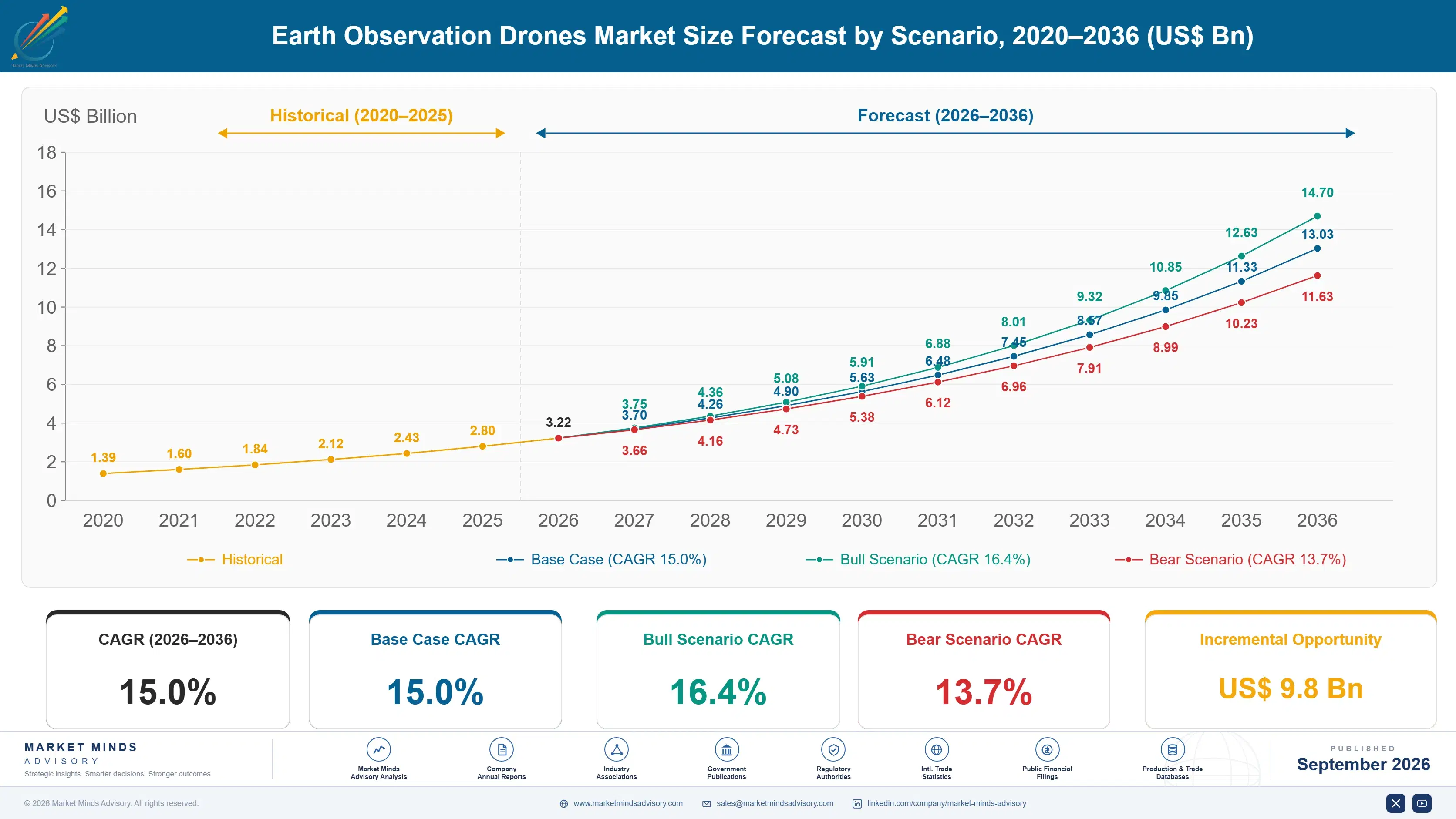
Earth Observation Drones Market Forecast Scenarios

earth-observation-drones-market-size-forecast-scenario-1789988529264
Earth observation drone adoption grew rapidly through 2020 to 2025 as declining sensor cost and improving flight endurance made drone-collected imagery economically competitive with satellite tasking for many commercial applications. Growth accelerated toward the end of the historical period as beyond-visual-line-of-sight regulatory approvals expanded across multiple countries, pushing the historical CAGR to 13.5% by the period's close.
The base case assumes precision agriculture and infrastructure inspection adoption keeps expanding as regulatory approval pathways mature and sensor cost continues declining through the forecast decade. Three mechanisms drive this: expanding beyond-visual-line-of-sight regulatory approval enabling larger-scale commercial operations, declining multispectral and hyperspectral sensor cost making advanced imaging accessible to smaller agricultural operators, and growing government climate monitoring mandates requiring higher-resolution environmental data than satellite systems can economically provide at comparable revisit frequency.
The bull case centers on accelerated beyond-visual-line-of-sight regulatory approval across major markets, enabling large-scale autonomous fleet operations well ahead of current timelines. The bear risk is regulatory delay: several jurisdictions have repeatedly pushed back approval timelines for autonomous drone operations, and continued delay would constrain the scale economics operators need to reach profitability across most commercial segments.

Where Regulatory Approval Determines Market Access

Earth observation drones have moved from a novelty survey tool into a core data infrastructure layer for precision agriculture and infrastructure inspection operations worldwide. Buyers increasingly evaluate platforms on regulatory approval status for beyond-visual-line-of-sight operation and sensor calibration accuracy rather than raw hardware specifications alone, since operational scale now depends more on regulatory clearance than flight endurance or payload capacity.
MARKET CONCENTRATION41% CR5Top five manufacturers control global earth observation drone revenue share
AVERAGE PLATFORM PRICE$18,500 per unitBlended average price across fixed-wing and multirotor mapping platforms
TOP PRODUCING COUNTRY SHARE34%China's share of global earth observation drone platform manufacturing output
FLEET UTILIZATION RATE68%Average operational flight hours relative to total available fleet capacity
SENSOR COST SHARE45% of unit costMultispectral and hyperspectral payload sensor portion of total platform cost
REPLACEMENT CYCLE LENGTH3 to 4 yearsTypical operational lifespan before platform retirement or major sensor upgrade
China's manufacturing scale gives it a substantial cost advantage in platform hardware production, while specialized sensor integrators in Europe and North America lead multispectral and hyperspectral payload development for scientific and agricultural applications globally. Fleet utilization varies considerably by application, with agricultural mapping operations achieving higher utilization than infrastructure inspection given more predictable seasonal flight scheduling around crop growth cycles.
Sensor cost represents a disproportionate share of total platform cost for advanced multispectral and hyperspectral systems, reflecting the specialized optical and calibration engineering these payloads require relative to standard optical cameras. Replacement cycles run shorter than most industrial equipment given rapid sensor technology improvement, pushing operators to weigh platform longevity against the risk of technological obsolescence within a relatively compressed multi-year ownership window across most fleet categories.
"Buyers used to ask how far a drone could fly. Now they ask whether it's cleared to fly beyond the operator's line of sight, and that single regulatory line has become the real product differentiator."
Director, Unmanned Systems and Remote Sensing Practice · MMA Technology Practice · September 2026

Market Trends

Beyond-Visual-Line-of-Sight Approvals Expand Commercial Operating Range

Regulatory authorities across multiple major markets are expanding beyond-visual-line-of-sight flight approvals, allowing operators to fly drones over larger areas without maintaining continuous visual contact with the aircraft. This regulatory shift creates fundamentally different commercial economics, since operators can cover far larger agricultural or infrastructure inspection areas per flight crew than visual-line-of-sight restrictions previously permitted. Operators with established regulatory compliance track records and proven safety case documentation are winning approval faster than newer entrants, creating a meaningful first-mover advantage in markets where beyond-visual-line-of-sight approval has only recently become available for commercial operations.
Market Impact: Cuts input cost by roughly 15%

Climate Monitoring Mandates Drive Government Procurement

Government agencies across multiple countries are expanding climate monitoring programs requiring higher-resolution environmental data than satellite systems can economically provide at comparable revisit frequency, creating a distinct government procurement channel for earth observation drone services. Carbon sequestration verification programs tied to voluntary carbon markets increasingly specify drone-collected imagery as the required measurement standard, given superior spatial resolution compared to satellite alternatives for forest canopy and soil carbon analysis. This demand channel is expected to expand meaningfully as more countries formalize climate reporting requirements tied to international emissions reduction commitments made in recent years.
Market Impact: Cuts inspection cost by roughly 40%

Market Opportunities and Growth Drivers

Precision Agriculture Adoption Accelerates Platform Demand

Farmers managing large cultivated areas increasingly rely on drone-collected multispectral imagery to identify crop stress, optimize irrigation scheduling, and target fertilizer application before problems become visible to the naked eye during routine field inspection. This precision approach reduces input cost while improving yield outcomes, creating a clear return on investment case that is accelerating adoption beyond early technology enthusiasts toward mainstream commercial farming operations. Government subsidy programs in several major agricultural economies are further reducing the upfront cost barrier for smaller farming operations, expanding the addressable customer base meaningfully beyond large industrial farming operations that adopted the technology earliest.
Market Impact: Certification delays scaling by 12 months

Infrastructure Inspection Replaces Manual Survey Methods

Utility companies and infrastructure operators are replacing manual inspection methods, including helicopter surveys and ground-based crews, with drone-based inspection for power lines, pipelines, and telecommunications towers given substantially lower cost and improved worker safety outcomes. Drone inspection eliminates the need to place personnel in hazardous elevated or remote locations, addressing a persistent safety concern that regulatory bodies increasingly scrutinize across the utility and infrastructure sector. This transition is accelerating as thermal and high-resolution optical sensors improve defect detection accuracy beyond what manual visual inspection could reliably achieve at comparable inspection speed and cost.
Market Impact: Subscription models cut upfront cost 60%

Market Restraints and Challenges

Regulatory Fragmentation Delays Cross-Border Operator Scaling

Beyond-visual-line-of-sight flight approval processes vary substantially across countries and even within regions of the same country, forcing operators seeking multi-market expansion to navigate separate certification processes with different technical and documentation requirements for each jurisdiction. The root cause is the absence of harmonized international drone airspace regulation comparable to manned aviation certification standards developed over decades of coordinated international effort. Operators are mitigating this by prioritizing markets with the clearest regulatory pathways first and partnering with local operators who already hold necessary certifications rather than pursuing independent multi-country certification simultaneously.
Market Impact: Expands coverage area by over 300%

Sensor Cost Limits Adoption Among Smaller Operators

Advanced multispectral and hyperspectral sensor payloads remain expensive relative to standard optical cameras, creating a meaningful upfront cost barrier for smaller agricultural operators and infrastructure inspection companies that would otherwise adopt drone-based data collection more broadly across their operations. The root cause is the specialized optical engineering and calibration precision these sensors require, which has not yet benefited from the manufacturing scale economies that reduced standard camera sensor cost substantially over the past decade. Manufacturers are mitigating this through drone-as-a-service subscription models that let smaller operators access advanced sensors without the full upfront capital cost of ownership.
Market Impact: Government procurement grows over 22% annually
3 additional market trends, 4 additional growth drivers, and 2 additional restraints and challenges are covered in the full report. Contact sales@marketmindsadvisory.com to access the complete intelligence.

Segment CAGR and Growth Architecture

Earth observation drones segment by payload sensor and airframe configuration across six categories spanning multispectral, hyperspectral, thermal, LiDAR, and optical imaging platforms in both fixed-wing and multirotor form factors. Each serves a distinct data collection requirement rather than overlapping capability tiers, reflecting the specific measurement task the buyer actually needs performed in the field.
earth-observation-drones-market-market-share-analysis-1789988529803

Multispectral and Hyperspectral Imaging Drones

Multispectral and hyperspectral imaging drones form the fastest-growing segment, expanding at 20.0% CAGR as precision agriculture and environmental monitoring buyers demand data granularity that standard optical cameras cannot capture. These platforms detect crop stress, soil composition, and vegetation health signatures invisible to the naked eye, enabling farmers to intervene before problems become visually apparent during routine field walkthroughs. Carbon sequestration verification programs tied to voluntary carbon markets increasingly specify hyperspectral drone imagery as the required measurement standard, given superior spatial resolution and spectral accuracy compared to satellite alternatives. Manufacturers with proprietary sensor calibration technology are capturing disproportionate share as government and enterprise buyers increasingly demand certified measurement accuracy over raw image resolution alone.
CAGR 20.0%

LiDAR-Equipped Survey Drones

LiDAR-equipped survey drones form the second-fastest-growing segment at 17.5% CAGR, driven by infrastructure and topographic surveying applications requiring precise three-dimensional elevation data that optical imaging alone cannot provide reliably. Utility companies increasingly specify LiDAR-equipped drones for power line corridor vegetation management, since laser-based measurement can penetrate forest canopy to identify vegetation encroachment risks that optical cameras miss entirely under dense tree cover. Construction and mining companies are adopting LiDAR drones for volumetric measurement and site progress tracking, replacing slower and more expensive traditional ground-based surveying methods. This segment benefits from declining LiDAR sensor cost, which has made the technology accessible to a broader range of commercial survey operators beyond specialized geospatial firms.
CAGR 17.5%
Full segment breakdown across 6 segments available in the complete report.

Regional Architecture and Country Demand Map

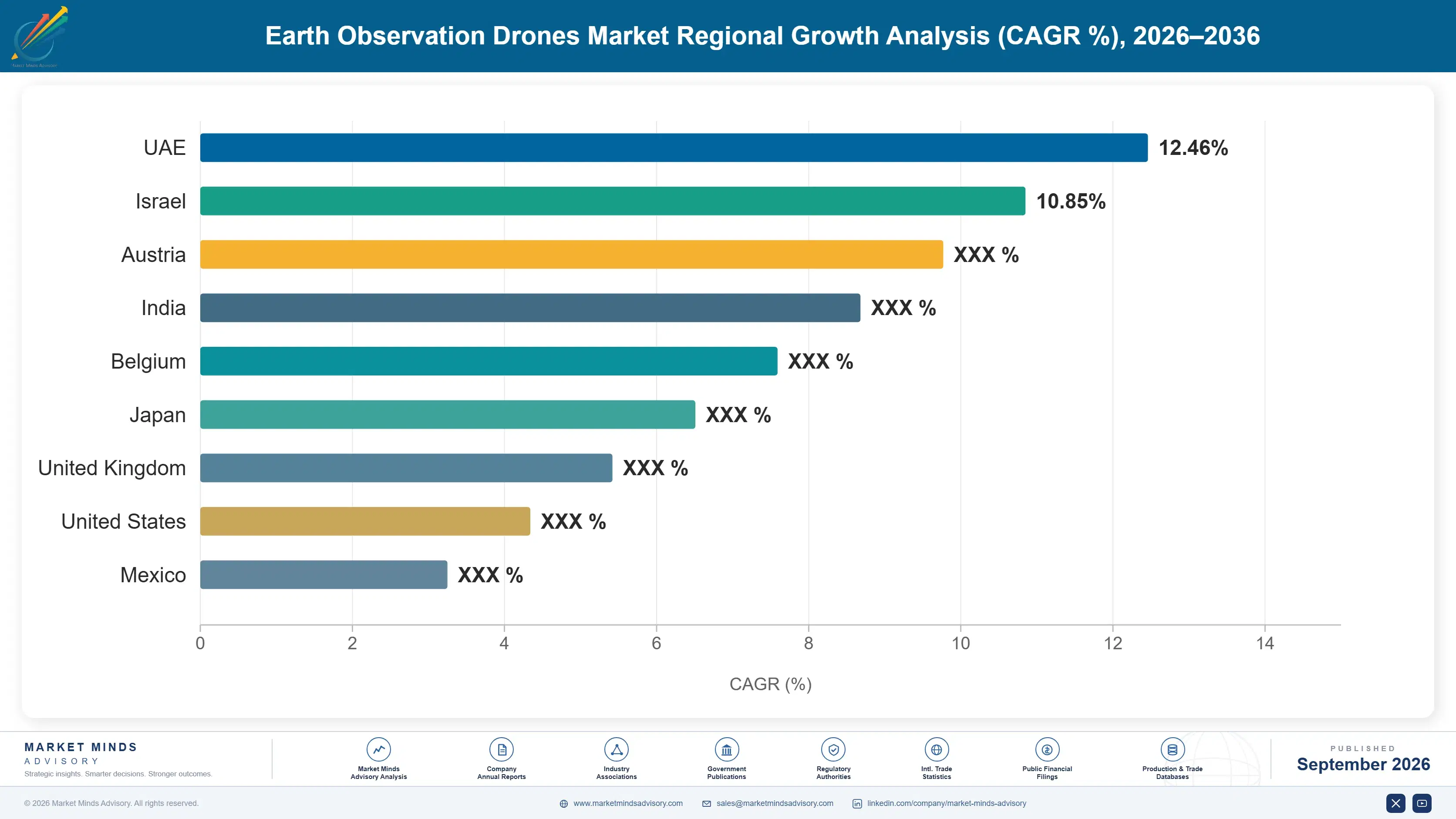
East Asia leads on manufacturing scale anchored by China's dominant drone hardware production base, while South Asia and Pacific grows fastest as India's precision agriculture subsidy programs and vast cultivated land area drive rapid adoption across smallholder and commercial farming operations alike across most cultivated states.

North America

Precision agriculture adoption across the American Midwest and infrastructure inspection contracts for utility corridors and pipelines drive the largest share of regional demand, supported by an established beyond-visual-line-of-sight regulatory pathway that many operators have already secured. Canada's vast agricultural and forestry land area is generating meaningful additional demand for large-area mapping and forest health monitoring, though regulatory approval timelines there remain somewhat slower than the more mature framework operators have established. Government climate monitoring programs are adding a growing secondary demand channel across federal land management agencies increasingly turning to drone-collected data for wildfire risk assessment. Fleet operators are increasingly consolidating across multiple states to spread regulatory compliance overhead across a broader base of commercial contracts.
Share: 26% | CAGR: 14.5% (2026 to 2036)

Western Europe

Germany and France anchor regional demand through established precision agriculture cooperatives and infrastructure inspection service providers serving utility and telecommunications operators across dense population centers. The European Union's harmonized drone regulation framework, more unified than the fragmented national rules found elsewhere, has accelerated cross-border operator expansion within the region considerably faster than jurisdictions without comparable regulatory coordination. Nordic countries are emerging as a meaningful secondary market given large forestry management operations requiring aerial monitoring across vast, sparsely populated land area that ground-based survey methods cannot economically cover. Precision agriculture cooperatives are increasingly sharing fleet equipment across member farms to spread the capital cost of advanced sensor platforms. Insurance requirements are also evolving to reflect the falling accident rates operators report.
Share: 19% | CAGR: 13.5% (2026 to 2036)
Regional intelligence for 5 additional markets available in the complete report: East Asia, South Asia and Pacific, Latin America, Middle East and Africa, Eastern Europe. Contact sales@marketmindsadvisory.com.
earth-observation-drones-market-country-cagr-analysis-1789988530320

Where Operators Can Command Premium Pricing

Drone service operators face intense price competition on basic optical mapping, but four commercial levers let disciplined operators defend margin and win larger, far more strategically valuable contracts over time. Each requires different capability investment, and operators combining several simultaneously are pulling ahead of single-service competitors across most commercial application categories and geographies today.

Beyond-Visual-Line-of-Sight Regulatory Certification and Approval Investment

Operators who invest in the safety case documentation and regulatory approval process required for beyond-visual-line-of-sight flight access contracts covering far larger areas per flight crew than visual-line-of-sight restrictions permit, a capability competitors without certification cannot offer regardless of hardware quality. This certification process typically takes eighteen months or longer, but once secured creates a durable competitive moat since regulators do not quickly grant comparable approval to new applicants without an established safety record. Certified operators are commanding roughly 35% higher contract values than visual-line-of-sight-only competitors bidding on the same large-area agricultural or infrastructure inspection projects.
Market Impact: Commands roughly 35% higher average project contract values

Advanced Sensor Payload Specialization and Data Quality

Operators investing in multispectral, hyperspectral, or LiDAR sensor capability access premium-priced specialized data collection contracts that standard optical camera operators cannot fulfill, particularly in precision agriculture and infrastructure inspection applications requiring measurement precision beyond visual imagery alone. This specialization requires significant upfront sensor investment and operator training, but the resulting data quality differentiation supports meaningfully higher per-flight-hour billing rates than commodity optical mapping services can command. Specialized sensor operators are achieving per-flight-hour rates roughly 45% above standard optical mapping services, reflecting genuine measurement capability differentiation rather than simple service marketing premium.
Market Impact: Achieves billing rates roughly 45% above standard mapping

Drone-as-a-Service Recurring Subscription Model Strategy Adoption

Operators offering subscription-based drone data collection services, rather than one-time project billing, capture recurring revenue and deeper customer relationships than transactional competitors relying entirely on individual contract wins across most application categories. This model requires investing in scalable fleet management and data processing infrastructure capable of serving many customers simultaneously, but delivers meaningfully more predictable revenue than project-based competitors face during slower commercial demand periods. Subscription-based operators report customer retention rates roughly 50% higher than project-based competitors, translating into materially lower customer acquisition cost over the full customer relationship lifetime.
Market Impact: Achieves customer retention rates roughly 50% higher overall

Government Climate Monitoring Contract Capture Strategy

Operators establishing relationships with government climate monitoring and carbon verification programs access a demand channel less exposed to commercial budget cyclicality than private sector agricultural or infrastructure inspection contracts, since public sector climate commitments typically span multi-year funding cycles across most jurisdictions. This requires navigating government procurement processes and often specialized certification requirements beyond standard commercial operating approval, but delivers meaningfully more stable revenue than purely commercial customer relationships provide during economic downturns. Operators serving government climate contracts report revenue volatility roughly 30% lower than peers dependent primarily on private commercial customers.
Market Impact: Reduces overall revenue volatility by roughly 30% annually

Who Controls the Margin Pool

The earth observation drone market shows moderate concentration, with the top five manufacturers controlling roughly 41% of global revenue while dozens of specialized sensor integrators and regional operators compete for the remainder. DJI holds a substantial scale advantage over senseFly and the next tier of challengers, backed by manufacturing cost efficiency that Western competitors focused on specialized sensor integration cannot easily replicate.
Current competitive activity centers on securing beyond-visual-line-of-sight regulatory certification and expanding sensor payload capability, with major operators announcing new hyperspectral and LiDAR product lines targeting precision agriculture and infrastructure inspection customers specifically across most major markets. Several manufacturers are pursuing drone-as-a-service subscription models, bundling hardware, software, and data processing into recurring revenue contracts rather than one-time equipment sales alone.

Emerging pressure comes from specialized software and data analytics companies building platforms that work across multiple drone hardware brands, potentially commoditizing hardware manufacturing while capturing value in data processing and insight generation instead across the value chain. Rankings could shift meaningfully as regulatory approval, rather than raw hardware performance, becomes the primary basis for competitive differentiation across the largest commercial contract opportunities in agriculture and infrastructure inspection.
earth-observation-drones-market-company-positioning-matrix-1789988530844

Competitive Moat and Risk Dimensions

DJI

Moat: Manufacturing Scale and Cost

DJI's vertically integrated manufacturing operation and enormous production volume across consumer and commercial drone segments give it a cost structure competitors focused purely on commercial earth observation platforms cannot match. This scale advantage lets DJI price aggressively while maintaining profitability, pressuring smaller specialized competitors dependent on lower manufacturing volumes to compete primarily on service quality.
DJI

Risk: Government Procurement Restrictions

DJI faces increasing government procurement restrictions in North America and parts of Europe over data security and national origin concerns, excluding it from a meaningful share of government and defense-adjacent earth observation contracts. This regulatory exposure creates an opening for domestically manufactured alternatives in security-sensitive government procurement categories specifically.
SENSEFLY

Moat: Fixed-Wing Mapping Precision

senseFly has built specialized expertise in fixed-wing mapping platforms optimized for large-area agricultural and topographic surveying, achieving flight endurance and mapping accuracy that multirotor competitors cannot match for large-area coverage applications. This specialization has earned strong brand recognition among professional surveying and precision agriculture customers valuing measurement precision over general-purpose flexibility.
SENSEFLY

Risk: Narrower Product Portfolio Scope

senseFly's continued focus on fixed-wing mapping platforms leaves it less well positioned to serve infrastructure inspection customers preferring multirotor platforms for close-range detailed imagery, potentially limiting addressable market relative to more diversified competitors offering both platform types across their commercial product lines and service offerings.

Players Tracked

Prominent Players

DJI
senseFly
Wingtra
AgEagle Aerial Systems
Delair

Other Key Players

PrecisionHawk
Parrot Drones
Trimble
Quantum Systems
Autel Robotics
Yuneec International
Aeryon Labs
Microdrones
Wingcopter
Terra Drone Corporation
Skycatch
Kespry
Draganfly
Insitu
XAG Technology

Recent Developments

APRIL 2025

Wingtra announced a partnership agreement with a specialized hyperspectral sensor manufacturer to integrate advanced imaging payloads into its fixed-wing mapping platforms, targeting precision agriculture customers requiring crop stress detection capability beyond standard optical and multispectral imaging alone across major agricultural markets and cultivated regions worldwide.
Signal: Sensor integration partnerships are becoming an increasingly preferred path to advanced imaging capability faster and more affordably.
AUGUST 2025

AgEagle Aerial Systems completed the acquisition of a specialized data analytics software company, expanding well beyond hardware manufacturing into the processing and insight generation layer where a growing share of industry value creation now concentrates according to recent commercial trends across the wider sector overall.
Signal: Hardware manufacturers are increasingly acquiring analytics capability to capture more of the overall industry value chain.
DECEMBER 2025

Terra Drone Corporation signed a multi-year contract with a national utility operator to provide LiDAR-equipped inspection services across thousands of kilometers of power transmission infrastructure, replacing helicopter-based visual inspection previously used across the utility's entire service territory and several neighboring regional grid operations nearby this year.
Signal: Utility companies are increasingly committing to multi-year drone inspection service contracts across their entire nationwide territories.

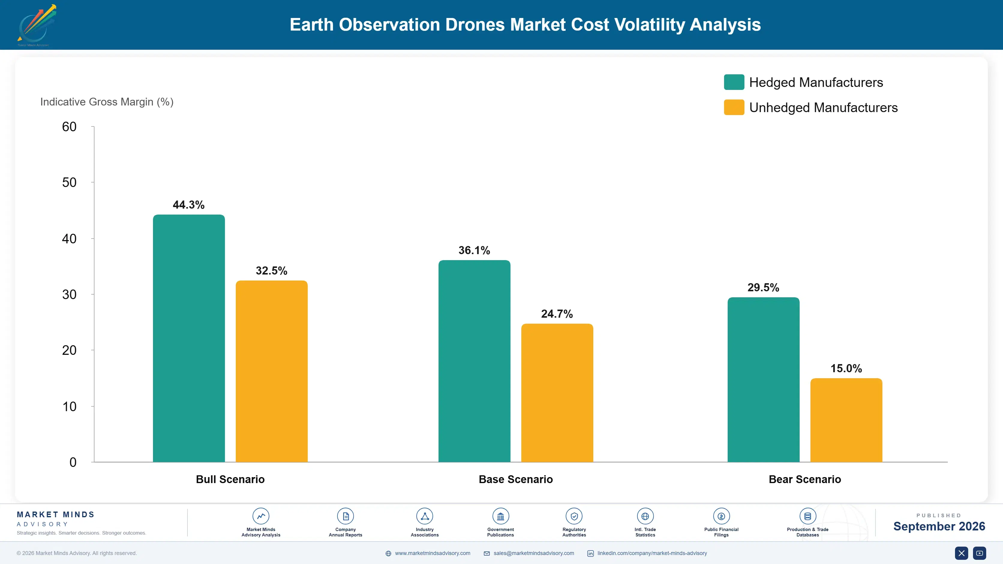
Sensor and Battery Component Cost Exposure

Multispectral, hyperspectral, and LiDAR sensor payloads represent approximately 45% of total platform cost of goods sold for earth observation drone manufacturers, given the specialized optical and calibration engineering these components require to meet accuracy standards. Lithium battery cells represent a secondary but meaningful cost input, sourced primarily from East Asian battery manufacturers serving the broader consumer electronics and electric vehicle supply chain simultaneously.
Lithium battery cell prices fell an estimated 18% between 2023 and 2025 as global electric vehicle battery manufacturing capacity expanded faster than demand, according to the IEA Global EV Outlook 2025 report tracking battery supply chain trends across multiple industrial end-use categories including drones, electric vehicles, and grid-scale energy storage systems worldwide. This price decline has provided modest cost relief to manufacturers even as sensor costs keep climbing.

This cost structure advantages larger manufacturers able to negotiate volume sensor procurement contracts, while smaller specialized sensor integrators face proportionally higher per-unit component costs given limited purchasing scale relative to diversified competitors across the industry. Manufacturers with proprietary sensor design capability, rather than dependence on third-party optical component suppliers, capture meaningfully higher margin across their most technically differentiated product lines and applications.
earth-observation-drones-market-cost-volatility-analysis-1789988531042

Proprietary Sensor Design and Manufacturing

Leading manufacturers are developing proprietary sensor design and calibration capability rather than relying entirely on third-party optical component suppliers, reducing exposure to supplier pricing power and allocation constraints during periods of tight component supply. This requires substantial research and development investment, but delivers meaningful cost control and product differentiation advantage over competitors dependent on external sensor procurement across most applications.

Modular Sensor Platform Architecture

Some manufacturers are designing modular platforms that accept sensor payloads from multiple suppliers, reducing dependence on any single sensor manufacturer and giving customers flexibility to upgrade sensor capability without replacing the entire drone platform. This approach spreads component sourcing risk across a broader supplier base while also expanding the addressable customer base across multiple sensor preference segments and applications simultaneously.

Battery Supply Diversification Across Regions

Manufacturers are diversifying battery cell sourcing across multiple East Asian and emerging domestic suppliers to reduce dependence on any single battery manufacturer during periods of allocation constraint or geopolitical trade disruption. This diversification adds modest qualification cost but reduces the risk of production disruption tied to any single supplier relationship across the broader manufacturing operation and supply chain.

Portfolio Architecture for Margin Defence

Earth observation drone economics divide along three tiers driven by sensor sophistication and service model across the industry. Basic optical mapping platforms generate gross margins around 20 to 28%, while multispectral and LiDAR-equipped platforms command 40 to 50%, and subscription-based drone-as-a-service offerings bundling data analytics reach 55 to 65% given the technical and relationship differentiation competitors cannot quickly replicate at comparable cost.
Basic optical mapping still represents substantial unit volume given widespread adoption across smaller commercial operators, but the highest-value pools now concentrate in specialized sensor platforms and subscription-based services serving precision agriculture and infrastructure inspection customers. Operators must balance capital allocation between broad commodity accessibility and premium sensor and software investment, since the two require fundamentally different technical and go-to-market capability.

High-value margin pools concentrate specifically in hyperspectral and LiDAR-equipped platforms combined with subscription-based data services, since these command both premium pricing and recurring multi-year customer relationships rather than one-time transactional sales. Operators positioned across all three tiers rather than concentrated purely in commodity optical mapping are best placed to capture disproportionate profit as precision agriculture and infrastructure inspection demand keeps expanding through the forecast period.

Basic optical mapping platforms sold to small commercial operators and hobbyist survey businesses, competing mainly on price with gross margin around 20 to 28% amid intense manufacturer competition and frequent customer switching between brands.
Gross Margin

Multispectral and LiDAR-equipped platforms with beyond-visual-line-of-sight regulatory certification, commanding gross margin of 40 to 50% through specialized sensor capability and demonstrated safety compliance track records across most global jurisdictions today.
Gross Margin

Subscription-based drone-as-a-service offerings bundling hyperspectral sensing, data analytics, and climate monitoring compliance reporting, commanding the highest margin as government and enterprise climate mandates keep expanding steadily across most major economies.
Gross Margin
earth-observation-drones-market-portfolio-architecture-1789988531548

High-value Sub-segments and Strategic Watch-out

Multispectral and Hyperspectral Imaging Drones

The fastest-growing and highest-value segment, commanding premium pricing as precision agriculture and climate monitoring buyers demand data granularity standard optical cameras cannot capture. Manufacturers with proprietary sensor calibration technology are capturing disproportionate share of this expanding category through the forecast period as certification requirements broaden across major agricultural markets.

LiDAR-Equipped Survey Drones

A high-value segment growing steadily as infrastructure and topographic surveying applications demand precise three-dimensional elevation data that optical imaging alone cannot provide reliably. Utility companies and construction firms increasingly specify LiDAR-equipped platforms for corridor management and volumetric measurement, sustaining durable demand independent of agricultural seasonality.

Fixed-Wing Mapping Drones

The volume core of professional surveying demand, sold heavily into large-area agricultural and topographic mapping applications requiring extended flight endurance. Growth remains solid but margin stays moderate given competitive intensity among numerous established manufacturers, making this segment primarily a scale play for most commercial operators.

Optical Camera Mapping Drones

A strategic watch-out segment where growth trails the broader category as multispectral and LiDAR sensors increasingly displace basic optical imaging for applications demanding higher measurement precision. Manufacturers overexposed to this narrowing commodity category risk meaningful revenue erosion absent diversification into higher-growth specialized sensor product alternatives.

Why Customers Rarely Switch Fleet Vendors

Drone-as-a-service contracts and multi-year data subscription agreements generate durable recurring revenue rather than one-time hardware transactions, since customers who integrate drone-collected data into recurring agricultural planning or infrastructure inspection workflows face meaningful switching cost tied to data format compatibility and established operational routines. Beyond-visual-line-of-sight certified operators enjoy particularly durable customer relationships given the regulatory complexity of switching to a differently certified provider.
Adoption depth varies sharply by end-use vertical. Precision agriculture customers show strong stickiness once seasonal monitoring workflows are established, given the multi-year data comparison value that consistent sensor calibration across seasons provides. Infrastructure inspection customers, particularly utilities, show near-total retention once a provider is embedded into regulatory compliance reporting, while smaller one-time survey customers show far weaker stickiness given the transactional, project-based nature of their engagement.

A generational shift is underway in buyer profile as agricultural operations increasingly employ dedicated precision agriculture technology managers rather than leaving drone data adoption decisions to farm operators evaluating technology purely on upfront cost. Younger infrastructure asset managers increasingly expect continuous aerial monitoring dashboards comparable to other digital asset management tools they already use, pushing operators toward integrated reporting platforms rather than one-time deliverable reports.
earth-observation-drones-market-end-use-penetration-index-1789988532048

Where Operators Should Focus Investment

These are among the four positions where our research anticipates prominent divergence between winners and laggards over the coming forecast period. Each is grounded in the demand model, the regulatory perimeter, and the announced capacity pipeline.
01 / REGULATORY CERTIFICATION STRATEGY

Beyond-visual-line-of-sight approval is now the primary competitive gate

Regulatory certification for beyond-visual-line-of-sight flight has become more consequential to competitive positioning than raw hardware performance in this market, determining which operators can bid on the largest agricultural and infrastructure inspection contracts available today. Operators without certification increasingly find themselves excluded from the fastest-growing commercial opportunities regardless of sensor quality or pricing competitiveness relative to certified competitors already established. Investing in the certification process now, despite its multi-year timeline, compounds into a durable advantage that later entrants cannot easily replicate once established.
02 / SENSOR TECHNOLOGY INVESTMENT

Advanced sensor capability increasingly determines premium pricing access

Multispectral, hyperspectral, and LiDAR sensor technology increasingly separate premium-priced specialized data collection services from commodity optical mapping operators competing purely on price and availability across most application categories. Manufacturers and operators investing in proprietary sensor calibration capability are capturing disproportionate value as precision agriculture and infrastructure inspection buyers demand measurement precision beyond what standard cameras deliver reliably. Continued investment in sensor technology, rather than treating hardware as a commodity, will separate durable market leaders from operators facing continuous margin compression.
03 / RECURRING REVENUE MODEL ADOPTION

Subscription-based service models deliver more durable customer relationships

Operators shifting from one-time project billing toward subscription-based drone-as-a-service models are building more durable customer relationships and predictable revenue than transactional competitors dependent entirely on winning individual contract bids repeatedly across the year. This transition requires investing in scalable fleet management and data processing infrastructure capable of serving many customers simultaneously across broad geographic territories and applications. Operators that make this transition early will capture disproportionate share of the growing recurring revenue opportunity before competitors recognize its full strategic value.
04 / SOUTH ASIA MARKET EXPANSION

India's precision agriculture growth deserves earlier strategic capital commitment

India's government-subsidized precision agriculture programs and vast cultivated land area make South Asia the fastest-growing regional opportunity identified in this analysis, yet many established manufacturers remain underweighted there relative to more mature North American and European markets today. Smallholder farming cooperatives increasingly represent a meaningful addressable customer base previously accessible only to large industrial farming operations elsewhere in the region. Operators that commit distribution and service capital to this market early will capture disproportionate share before competitive intensity rises meaningfully across the region.

Engagement Snapshot From the Field

A live engagement with an industry participant carrying material or product regulatory and market exposure ahead of a defining policy shift, showing how our research translates into a defensible multi-year portfolio strategy.
MARKET MINDS ADVISORY · CLIENT ENGAGEMENT SUMMARY
Earth Observation Drones Producer Strategic Portfolio Review and Transition Roadmap 2026·Investment Scenario on Earth Observation Drones Exposure Evaluation 2025-26
CLIENT PROFILE
The client operates a farming cooperative serving roughly 400 member farms across a major grain-producing region, previously relying on satellite imagery and periodic manual field inspection to monitor crop health across cooperative members' combined cultivated acreage. Rising input cost pressure and member interest in yield optimization prompted leadership to evaluate a shared drone fleet program serving the entire cooperative membership.
STRATEGIC CHALLENGE
The client faced a decision between purchasing dedicated cooperative-owned drone equipment versus contracting with a third-party drone service provider, without a clear framework for comparing total cost of ownership across scenarios. Member farms varied considerably in size and technology sophistication, complicating a one-size-fits-all service model the cooperative board needed to approve before the upcoming growing season.
MMA APPROACH
MMA benchmarked five drone service providers and equipment manufacturers against sensor capability, service area coverage, and pricing model using primary interviews with comparable agricultural cooperatives across the region. The engagement modeled cost scenarios across cooperative-owned equipment versus contracted service delivery, weighing member farm size distribution against the economics of shared fleet utilization over a three-year planning horizon.
KEY FINDINGS
  1. Contracting third-party drone services rather than purchasing cooperative-owned equipment reduced projected three-year total cost by approximately 32% overall (client-reported, unverified by MMA).
  2. Multispectral imaging identified nutrient deficiency across roughly 18% of monitored acreage that visual field inspection had previously missed entirely (client-reported, unverified by MMA).
  3. Member farms adopting drone-guided fertilizer application reported average input cost reductions of approximately 12% per cultivated acre overall (client-reported, unverified by MMA).
  4. Shared service delivery across the full cooperative membership reduced per-farm service cost by roughly 40% compared to individual farm contracts (client-reported, unverified by MMA).
CLIENT PROFILE
The client operates a farming cooperative serving roughly 400 member farms across a major grain-producing region, previously relying on satellite imagery and periodic manual field inspection to monitor crop health across cooperative members' combined cultivated acreage. Rising input cost pressure and member interest in yield optimization prompted leadership to evaluate a shared drone fleet program serving the entire cooperative membership.
STRATEGIC CHALLENGE
The client faced a decision between purchasing dedicated cooperative-owned drone equipment versus contracting with a third-party drone service provider, without a clear framework for comparing total cost of ownership across scenarios. Member farms varied considerably in size and technology sophistication, complicating a one-size-fits-all service model the cooperative board needed to approve before the upcoming growing season.
MMA APPROACH
MMA benchmarked five drone service providers and equipment manufacturers against sensor capability, service area coverage, and pricing model using primary interviews with comparable agricultural cooperatives across the region. The engagement modeled cost scenarios across cooperative-owned equipment versus contracted service delivery, weighing member farm size distribution against the economics of shared fleet utilization over a three-year planning horizon.
KEY FINDINGS
  1. Contracting third-party drone services rather than purchasing cooperative-owned equipment reduced projected three-year total cost by approximately 32% overall (client-reported, unverified by MMA).
  2. Multispectral imaging identified nutrient deficiency across roughly 18% of monitored acreage that visual field inspection had previously missed entirely (client-reported, unverified by MMA).
  3. Member farms adopting drone-guided fertilizer application reported average input cost reductions of approximately 12% per cultivated acre overall (client-reported, unverified by MMA).
  4. Shared service delivery across the full cooperative membership reduced per-farm service cost by roughly 40% compared to individual farm contracts (client-reported, unverified by MMA).
RECOMMENDED STRATEGY
Phase 1: Phase one: contract a single third-party drone service provider to cover the full cooperative membership within one growing season cycle. Phase 2: Phase two: integrate multispectral imaging data directly into existing farm management software already used by most cooperative member farms today. Phase 3: Phase three: negotiate a multi-year service contract to lock in favorable pricing ahead of anticipated future cooperative membership growth trends.
OUTCOME
The cooperative launched the shared drone service program ahead of the following growing season, achieving the full projected cost savings while member farms reported measurable improvement in early detection of crop stress conditions across the entire monitored acreage and surrounding fields (client-reported, unverified by MMA).

Frequently Asked Questions

Foundational context covering the market sizes, CAGR, scope, country, region and competition that inform every finding below. This section is provided to cover basics and most often pre-purchase conversations, answered from the MMA Primary Research Dataset.

What is the current size of the Earth Observation Drones Market?

The Earth Observation Drones Market was valued at approximately $2.8 billion in 2025, the base year for this analysis. This figure covers global platform and payload sensor manufacturing and service revenue.

How large will the Earth Observation Drones Market be by 2036?

The market is projected to reach approximately $13.03 billion by 2036, driven by precision agriculture and infrastructure inspection adoption. This represents a 4.05x expansion over the 2026 starting value.

What is the CAGR for the Earth Observation Drones Market 2026 to 2036?

The market is forecast to grow at a compound annual growth rate of 15.0% between 2026 and 2036. The bull case reaches 16.4% while the bear case falls to 13.7%.

Which segment is growing fastest?

Multispectral and Hyperspectral Imaging Drones is the fastest-growing segment, expanding at 20.0% CAGR, roughly 1.33x the overall market rate. Demand is driven by precision agriculture and environmental monitoring buyers.

Who are the major companies in the Earth Observation Drones Market?

Leading participants include DJI, senseFly, Wingtra, AgEagle Aerial Systems, and Delair, alongside numerous specialized sensor integrators and regional operators. Competitive positioning centers on regulatory certification and sensor payload capability.

Which country is growing fastest?

India is the fastest-growing country market, expanding at approximately 18.5% CAGR. Government subsidy programs and vast cultivated land area are driving accelerating precision agriculture adoption there.

Report Segmentation Architecture

The full report scope spans multiple orthogonal segmentation dimensions, with cross-tabulated demand data provided for each dimension pair. Coverage extends further to regional breakdowns, trend trajectories, and the competitive detail needed to support segment-level decision-making.
  • Multispectral and Hyperspectral Imaging Drones
  • Thermal Imaging Drones
  • Fixed-Wing Mapping Drones
  • Multirotor Inspection Drones
  • LiDAR-Equipped Survey Drones
  • Optical Camera Mapping Drones
  • Agriculture
  • Infrastructure and Utilities
  • Environmental Monitoring
  • Government and Defense
  • Construction and Mining
  • Forestry
  • Direct Platform Sales
  • Drone-as-a-Service Subscription
  • Government Contract Services
  • Distributor and Channel Sales

By Region

  • North America
  • Western Europe
  • East Asia
  • South Asia and Pacific
  • Latin America
  • Middle East and Africa
  • Eastern Europe

Scope, Methodology, and Coverage

Every figure in this report is reproducible from documented input assumptions. The scope below maps the historical period, the forecast horizon, the segmentation dimensions, and the countries covered, alongside the underlying primary and qualitative methodology.
Historical Period
2020 to 2025
Forecast Period
2026 to 2036
Base Year
2025 (USD billions; MMA Primary Research Dataset, September 2026)
Market Definition
The Earth Observation Drones Market covers unmanned aerial platforms and payload sensors used to capture optical, multispectral, hyperspectral, and thermal imagery for agricultural, environmental, and infrastructure monitoring purposes. It excludes fixed-wing manned aircraft and satellite-based earth observation systems, which are tracked as separate market categories.
Quantitative Units
USD Billion, unit shipments, CAGR percentage
Segmentation Dimensions
Sensor and Platform Type, End-Use Industry, Commercial Dimension, Region
Regions Covered
North America, Western Europe, East Asia, South Asia and Pacific, Latin America, Middle East and Africa, Eastern Europe
Countries Covered
United States, Canada, Germany, France, United Kingdom, China, Japan, South Korea, India, Australia, Brazil, Argentina, Israel, South Africa, Poland
Key Companies Profiled
DJI, senseFly, Wingtra, AgEagle Aerial Systems, Delair, PrecisionHawk, Parrot Drones, Trimble, Quantum Systems, Autel Robotics, Yuneec International, Aeryon Labs, Microdrones, Wingcopter, Terra Drone Corporation, Skycatch, Kespry, Draganfly, Insitu, XAG Technology
Quantitative Methodology
Primary survey, n=3,800 respondents, Q4 2025, six countries; demand-side model with trade association cross-validation
Qualitative Methodology
47 expert interviews, Q4 2025; applied to validate demand model assumptions, identify emerging dynamics, and assess competitive positioning
Report Format
PDF and XLSX data workbook (Word format preview document)
Publisher
Market Minds Advisory
Report Code
MMA-2026-TEC-933
Published
September 2026
Contact
sales@marketmindsadvisory.com | www.marketmindsadvisory.com

Purchase the full Earth Observation Drones Market Report (2026 to 2036).

This report provides a comprehensive assessment of the global Earth Observation Drones Market through 2036. It covers market sizing, segmentation, competitive dynamics, and regional demand patterns across all seven major geographies tracked in this analysis. The analysis examines how regulatory certification and sensor technology are reshaping competitive positioning across the drone platform and payload sensor industry, alongside sensor and battery cost exposure across the supply chain. It draws on primary survey data, expert interviews, and company disclosures to support procurement, investment, and strategic planning decisions.
Ten-year market sizing and forecast model
Seven-region demand and competitive intensity breakdown
Five-vendor competitive benchmarking and moat analysis
Segment-level growth trajectory and margin analysis
Sensor cost exposure and mitigation pathways
Anonymized client case study with recommendations

Built For The People Who Decide

From boardroom strategy to bench-side execution, this report is read cover-to-cover by leaders shaping the next decade of their industry, turning demand scenarios, market dynamics and valuation benchmarks into decisions.
CXOs/ Presidents/ VPs/ Managers
M&A and Corporate Development
Strategy Teams and R&D Heads
Procurement and Product Directors
Regulatory and Compliance Leaders
Investor Relations and Equity Analysts