
Market Minds Advisory
Construction Drones Market

Construction Drones Market: Construction Drones Market: BIM Integration and Structural Inspection Drive Adoption

Building information modeling integration and mounting infrastructure inspection mandates are pushing construction drones well beyond simple aerial photography, even as fragmented software environments across contractors slow how quickly captured data actually reaches project decision makers.

Lead Analyst

Published

September 2026

Make Smarter Decisions with Customized Research Insights

Request a free sample report and evaluate market opportunities, growth trends, and competitive dynamics relevant to your business needs.

2025 MARKET VALUE$3.2BMarket Size 2025
2036 FORECAST VALUE$11.1BBase Case , 2026 to 2036
CAGR 2026 TO 203612.0 %Bull 13.3% / Bear 10.7%
INCREMENTAL OPPORTUNITY$7.5BNet 10- year value creation
EXPANSION MULTIPLE3.11x2036 value over 2026 base
Strategic Levers
M&A Pipeline
Regional Outlook
Country Rankings
Competitive Intelligence
Segmental Deep-dive
Call-Us : 91 93563 13602

Executive Snapshot and Market Trajectory.

Construction drones are moving well beyond simple aerial photography as building information modeling integration turns captured flight data into structured project documentation that general contractors can act on directly rather than merely reference visually. Software platforms increasingly capture more value than the hardware capturing raw footage.
Structural inspection drones are growing fastest of six categories as aging infrastructure mandates expand demand, while safety and security monitoring drones follow closely on insurance-driven liability reduction interest. The United States concentrates the bulk of software-driven adoption given its deep construction technology supplier base. Suppliers with established building information modeling integration are winning disproportionate share of this accelerating demand. Flight waiver processing rules also shape which suppliers can compete.
Five suppliers hold roughly forty-eight percent of a genuinely fragmented market, led by DJI's hardware dominance and DroneDeploy's established software platform position. India's booming construction sector is driving the fastest national growth as infrastructure investment accelerates faster than traditional surveying methods can support. Regulatory approval timelines and fragmented construction software systems remain the two biggest friction points slowing broader adoption. That gap matters most for smaller firms lacking dedicated integration staff to manage this complexity.
Market Definition
This report covers revenue from drone hardware and software platforms sold for surveying, progress monitoring, structural inspection, thermal auditing, safety monitoring, and volumetric measurement applications on construction and infrastructure project sites. It excludes general aerial photography services unrelated to construction, drone platforms sold for non-construction commercial applications, and ground-based surveying equipment.
Base Year Value
$3.2B in 2025 (MMA Primary Research Dataset, August 2026)
Forecast Period
2026 to 2036, eleven discrete annual values
CAGR
12.0% base case. Bull 13.3%. Bear 10.7%.
Fastest Growth Segment
Structural Inspection Drones: 15.0% CAGR
Fastest Growth Country
India: 14.5% CAGR
Fastest Growth Region
South Asia and Pacific: 14.0% CAGR
Largest Region
North America: 28% of 2025 global value
Market Leaders
DJI, DroneDeploy, Skycatch, Propeller Aero, Pix4D. Source: MMA Analysis based on company annual reports and construction technology procurement disclosures.
Primary Survey
n=3,800 procurement and R&D decision-makers, Q4 2025, six countries
Methodology
Demand-side build-up, cross-validated against public data, 47 expert interviews

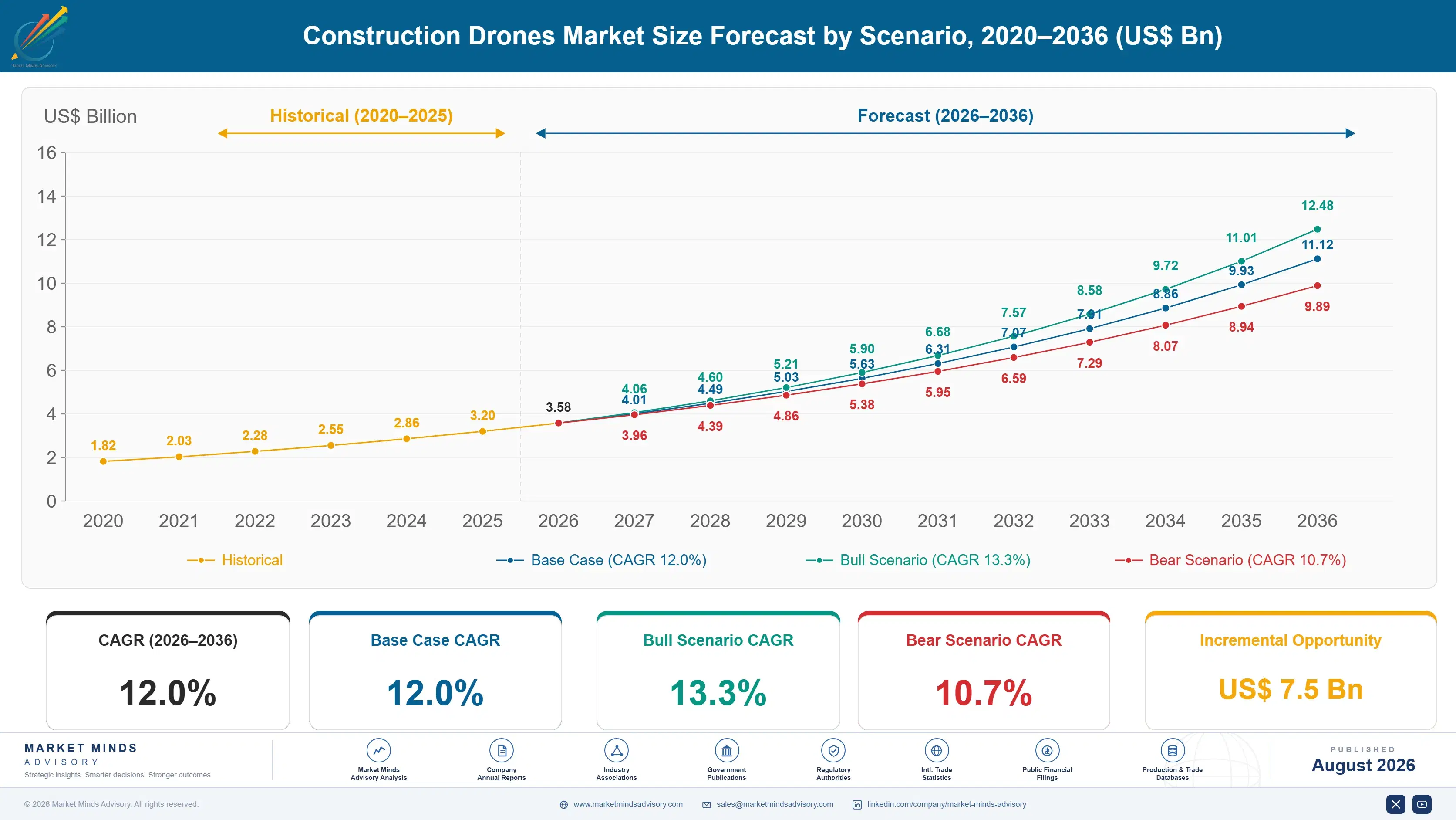
Construction Drones Market Forecast Scenarios

construction-drones-market-size-forecast-scenario-1787982234446
Between 2020 and 2025 the construction drones market grew at roughly 10.5 percent annually, accelerating as early aerial photography pilots evolved into structured surveying and progress monitoring workflows integrated with broader project management software. Software platforms established themselves as the differentiated value layer during this period as hardware became increasingly commoditized. Adoption broadened meaningfully once early results proved reliable across pilot programs.
The base case assumes 12.0 percent annual growth through 2036, anchored in three mechanisms: expanding building information modeling integration turning drone data into actionable project documentation rather than passive visual reference material, aging infrastructure inspection mandates requiring more frequent structural assessment than traditional methods can support affordably, and persistent construction labor shortages pushing surveying and monitoring toward automated aerial capture. Suppliers with structural inspection and BIM capability are best placed to capture this growth.
A bull scenario built on faster building information modeling adoption and accelerating infrastructure inspection mandates could push growth toward 13.3 percent. A bear scenario tied to regulatory flight restrictions and slower software integration progress could instead pull growth down toward 10.7 percent. Fragmented software integration progress remains a secondary swing factor either way. Software integration progress matters almost as much as regulation itself.

Data Integration Economics and Inspection Demand

Construction drone adoption sits at a genuine inflection point where hardware capability has matured well beyond what most construction firms actually capture value from, since raw aerial footage delivers only modest benefit until it integrates cleanly with the project management software teams already use daily. This gap between hardware capability and realized value is unusually wide for a mature technology category, and it defines the current competitive opportunity.
TOP-5 SUPPLIER CONCENTRATION48%Revenue share held by five largest hardware and software providers
BIM INTEGRATION ADOPTION RATE31%Construction projects currently integrating drone data with modeling software
STRUCTURAL INSPECTION ADOPTION22%Major infrastructure projects using drone-based structural assessment currently
AVERAGE SURVEY TIME REDUCTION65%Typical time savings achieved versus traditional ground-based surveying
SOFTWARE REVENUE SPLIT42% softwareShare of total market revenue tied to software platforms
WAIVER APPROVAL TIME45 daysTypical duration required to secure regulatory flight authorization
Software platform providers increasingly capture more value than pure hardware manufacturers, since the actionable insight construction firms actually pay for lives in data processing and building information modeling integration rather than in the drone hardware capturing raw flight footage itself. Hardware manufacturers increasingly recognize this dynamic, which is why several are pursuing software partnerships rather than trying to build integration capability from scratch internally.
Two forces will reshape the next decade. Building information modeling integration will keep deepening as software platforms mature beyond basic mapping toward genuine project management workflow integration, while infrastructure inspection mandates keep expanding demand for structural assessment capability regardless of broader construction spending cycles. Suppliers positioned to serve both the mature hardware market and the emerging regulatory-driven inspection segment simultaneously carry a genuine advantage.
"Everyone bought a drone thinking they were buying a camera. The ones actually getting value realized within a year that they were really buying a data pipeline, and the camera was just the cheapest part of it."
Director, Construction Technology Practice · MMA Construction and Industrial Equipment Practice · August 2026

Market Trends

BIM Integration Turns Flight Data Into Project Documentation

Building information modeling integration is transforming construction drones from aerial photography tools into structured data capture systems that feed directly into the three-dimensional project models general contractors already use for scheduling, budgeting, and coordination across trades. Software platforms increasingly automate converting raw flight footage into measurable volumetric data, progress percentages, and discrepancy flags project managers can act on directly. This integration depth increasingly determines which software platforms construction firms select, since the underlying drone hardware has become largely commoditized while the software layer connecting flight data to project workflows remains genuinely differentiated.
Market Impact: Cuts survey time 65 percent
Infrastructure Inspection Mandates Expand Structural Demand

Several jurisdictions have tightened bridge and infrastructure inspection requirements following high-profile structural failures, mandating more frequent assessment than traditional ground-based and human-accessed inspection methods can support affordably at current staffing levels. Drone-based structural inspection lets engineers assess hard-to-reach structural elements without scaffolding or lane closures that traditional inspection methods typically require, considerably reducing both cost and disruption to ongoing traffic or operations during the assessment process itself. Suppliers offering specialized structural inspection capability, including high-resolution imaging and thermal sensing for detecting subsurface deterioration, are capturing disproportionate share of this regulation-driven demand specifically.
Market Impact: Grows safety adoption 14 percent yearly

Market Opportunities and Growth Drivers

Persistent Construction Labor Shortages Push Surveying Automation

Construction firms worldwide face genuine difficulty recruiting sufficient skilled surveying and inspection personnel, making drone-based automated data capture an increasingly necessary substitute for traditional ground-based methods that require considerably more specialized labor per unit of site area covered. Drone-based surveying typically reduces the time required to complete a comprehensive site survey by roughly 65 percent compared with traditional ground-based methods, letting smaller surveying teams cover considerably more project sites than would otherwise be possible given current staffing constraints across the broader construction labor market. Insurance and financing partners increasingly recognize this efficiency gain when evaluating project risk.
Market Impact: Adds 45 days to project timelines

Insurance and Liability Pressure Drives Safety Monitoring Adoption

Construction site insurers and risk managers increasingly view drone-based safety monitoring as a genuine risk reduction measure worth incentivizing through premium adjustments, since continuous aerial monitoring can identify safety violations and hazardous conditions considerably faster than periodic manual walkthroughs alone typically achieve across large, complex construction sites. General contractors increasingly deploy safety monitoring drones specifically to demonstrate proactive risk management to insurers and regulators, treating this documentation as valuable liability protection beyond the direct safety benefit the monitoring itself provides during active construction operations. Several major insurers now offer premium discounts for sites running continuous drone monitoring.
Market Impact: Adds 15 percent to integration cost

Market Restraints and Challenges

Regulatory Flight Restrictions Limit Operational Flexibility

Drone flight near construction sites, particularly in urban areas close to airports or other restricted airspace, often requires regulatory waivers that typically take roughly forty-five days to secure, a timeline that sits awkwardly against the faster project schedules construction firms increasingly expect from every technology investment they make. The root cause is genuine aviation safety regulation designed for general airspace management rather than any specific hostility toward construction applications. Suppliers are mitigating this through pre-approved flight zone partnerships with regulators and standardized waiver application templates that reduce processing time for common construction site configurations specifically.
Market Impact: Reaches 31 percent BIM integration

Fragmented Software Environments Slow Data Integration

Construction firms typically run multiple, poorly integrated software systems across project management, scheduling, and building information modeling functions, creating genuine technical friction when drone data platforms attempt to connect captured flight data with existing project workflows already in daily use. The root cause is the construction industry's broader history of fragmented technology adoption rather than any specific shortcoming in drone software platforms themselves. Suppliers are mitigating this through standardized application programming interfaces and partnerships with major software providers, reducing friction for common configurations. Firms already using these provider platforms typically integrate new drone data sources more easily.
Market Impact: Affects 22 percent of major projects
3 additional market trends, 4 additional growth drivers, and 3 additional restraints and challenges are covered in the full report. Contact sales@marketmindsadvisory.com to access the complete intelligence.

Segment CAGR and Growth Architecture

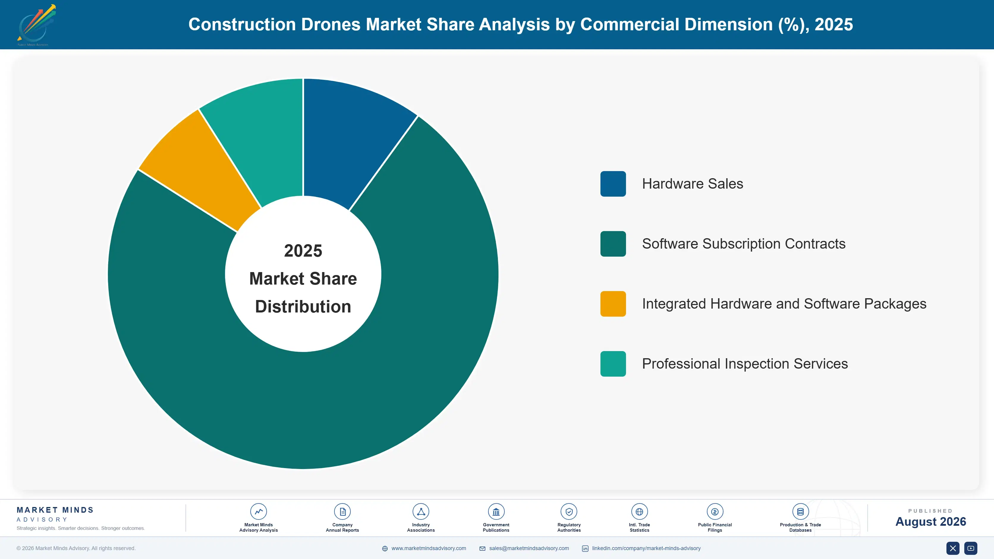
Segmentation follows application function, the dimension construction firms use to plan technology budgets and workflow integration. Six categories cover the market: surveying, progress monitoring, structural inspection, thermal auditing, safety monitoring, and volumetric measurement. This mirrors how construction firms themselves structure technology procurement and integration budget decisions. Regulators reference this same breakdown too. Software teams plan around this too.
construction-drones-market-market-share-analysis-1787982234976

Structural Inspection Drones

Structural inspection drones are growing fastest because several jurisdictions have tightened bridge and infrastructure inspection requirements following high-profile structural failures, mandating more frequent assessment than traditional ground-based methods can support affordably at current engineering staffing levels. Drone-based inspection lets engineers assess hard-to-reach structural elements without scaffolding or lane closures traditional methods typically require, considerably reducing both cost and disruption during the assessment process. Suppliers offering specialized capability including high-resolution imaging and thermal sensing for detecting subsurface deterioration are capturing disproportionate share of this regulation-driven demand. This segment commands meaningfully higher pricing than standard surveying applications given the specialized engineering expertise required to interpret inspection data accurately for safety-critical decisions. Regional infrastructure agencies increasingly reference this capability when drafting inspection standards.
CAGR 15.0%

Safety and Security Monitoring Drones

Safety and security monitoring drones are the second-fastest segment as insurers and risk managers increasingly view continuous aerial monitoring as a genuine risk reduction measure worth incentivizing through premium adjustments for construction firms that adopt it. Continuous monitoring identifies safety violations and hazardous conditions considerably faster than periodic manual walkthroughs alone typically achieve across large, complex construction sites with multiple active work zones simultaneously. General contractors increasingly deploy this capability specifically to demonstrate proactive risk management to insurers and regulators, treating the resulting documentation as valuable liability protection beyond the direct safety benefit monitoring itself provides during active operations. Suppliers offering integrated documentation alongside monitoring are winning disproportionate share of this insurance-linked demand.
CAGR 14.0%
Full segment breakdown across 6 segments available in the complete report.

Regional Architecture and Country Demand Map

North America leads on deep construction technology software supplier presence and high adoption rates. East Asia follows closely on China's massive construction volume, while South Asia and Pacific posts the fastest regional growth as India's infrastructure investment accelerates. Software adoption depth varies considerably more than hardware adoption itself does.

North America

The United States hosts the deepest concentration of construction technology software providers globally, including DroneDeploy, Skycatch, and Propeller Aero, giving the region genuine software platform leadership even though hardware manufacturing remains concentrated elsewhere. American general contractors have adopted building information modeling integration considerably faster than most international peers, reflecting the industry's broader digital transformation investment over the past decade specifically. Canadian construction firms separately drive meaningful demand tied to major infrastructure investment programs, typically procuring from the same software platforms dominant in the American market given close supplier relationships across the shared border. Suppliers straddling both hardware and software layers maintain a genuine strategic advantage in this technology-forward market. Growth here should stay steady overall.
Share: 28% | CAGR: 12.5% (2026 to 2036)

East Asia

China's unprecedented construction volume, spanning residential, commercial, and infrastructure projects simultaneously, drives substantial drone deployment even though most usage remains concentrated in basic surveying and progress monitoring rather than the more sophisticated building information modeling integration common in North America. DJI's domestic manufacturing dominance gives the region considerable hardware cost advantages that construction firms elsewhere cannot access as easily. Japanese and South Korean construction firms maintain smaller but more software-sophisticated deployment programs, typically procuring integration capability from both domestic and international suppliers depending on specific project requirements. Neither market yet matches North American software integration depth, though hardware cost advantages remain considerable. Domestic manufacturers increasingly export hardware at competitive prices to regional neighbors seeking similar cost advantages.
Share: 28% | CAGR: 13.0% (2026 to 2036)
Regional intelligence for 5 additional markets available in the complete report: Western Europe, South Asia and Pacific, Latin America, Middle East and Africa, Eastern Europe. Contact sales@marketmindsadvisory.com.
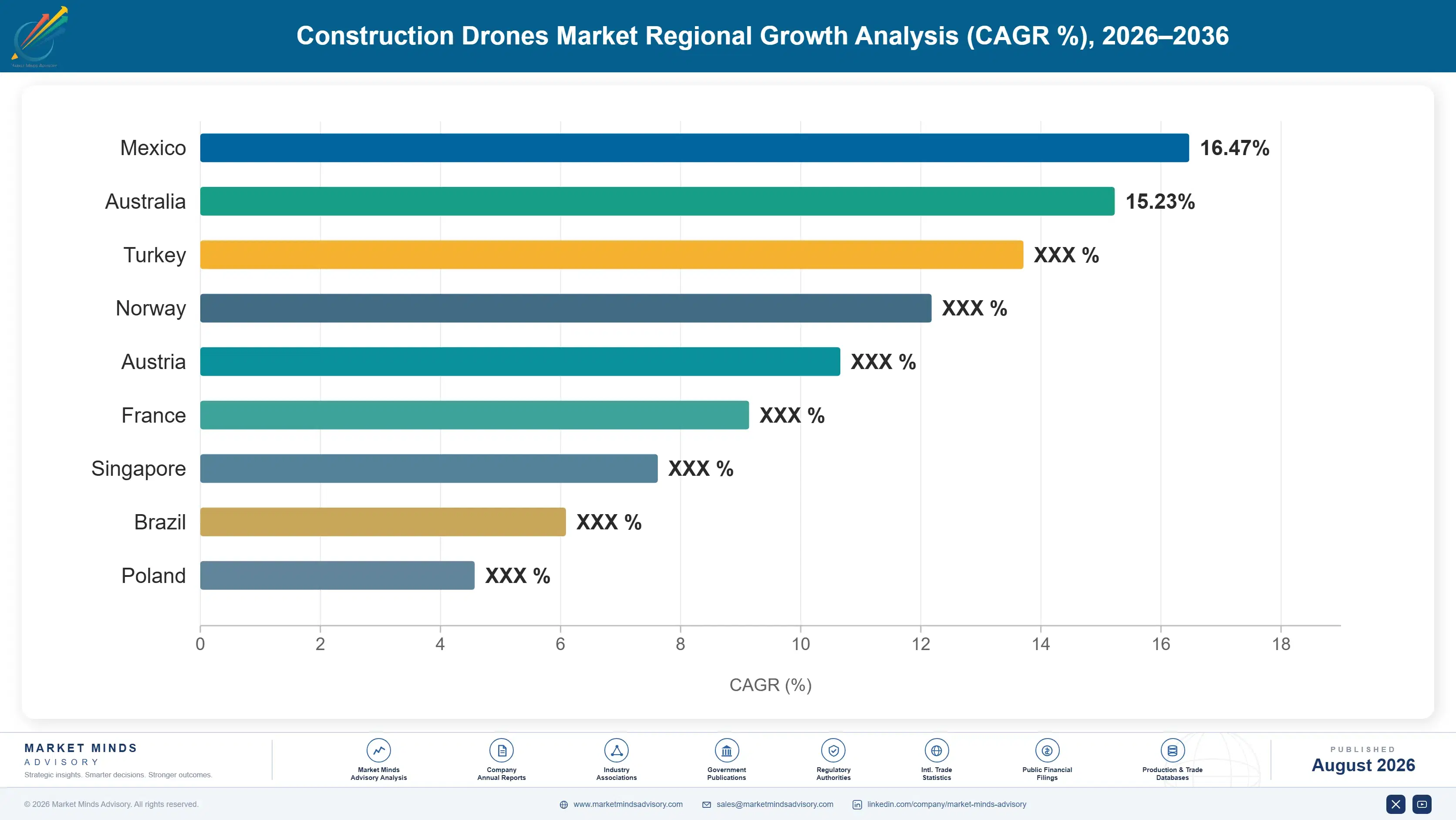
construction-drones-market-country-cagr-analysis-1787982235505

Where Drone Suppliers Can Capture Construction Growth

Four levers stand out for suppliers navigating a market shifting from commoditized hardware toward differentiated software integration. Each trades traditional hardware-only sales for either recurring software revenue, regulatory-driven demand, or capability differentiation competitors cannot easily match. Each requires different capabilities, but all four are available to suppliers already operating profitably today. Two are already widely available.

Deepen Building Information Modeling Integration Now

Only 31 percent of construction projects currently integrate drone data with building information modeling software, leaving considerable room for suppliers offering deeper integration to capture disproportionate share as construction firms increasingly prioritize this capability over basic aerial photography alone. Suppliers building genuine workflow integration, converting raw flight footage into measurable progress data and discrepancy flags automatically, can command meaningfully higher software subscription pricing than competitors offering standalone mapping tools. This approach also generates considerably more durable recurring revenue than one-time hardware sales alone provide, since integration depth increases switching costs for customers considerably.
Market Impact: Captures a full 31 percent of all integration

Build Specialized Structural Inspection Capability Fast

Structural inspection drones are growing at 15.0 percent annually against a 12.0 percent market average, driven by tightening infrastructure inspection mandates that traditional ground-based methods cannot support affordably at current engineering staffing levels. Suppliers offering specialized capability including high-resolution imaging and thermal sensing for detecting subsurface deterioration can command premium pricing given the specialized engineering expertise required to interpret inspection data accurately for safety-critical decisions. This regulation-driven demand also proves considerably more resilient during broader construction spending downturns than discretionary applications. Contractors increasingly seek suppliers who can demonstrate proven accuracy across comparable prior inspection assignments before committing.
Market Impact: Grows share within a fast 15 percent segment

Simplify Regulatory Waiver Application Processes Broadly

Regulatory flight waivers typically take roughly 45 days to secure, a timeline that sits awkwardly against faster project schedules construction firms increasingly expect. Suppliers that establish pre-approved flight zone partnerships with regulators and standardized waiver application templates can win contracts considerably faster than competitors requiring customers to navigate lengthy approval processes independently for each new project site. This approach also reduces customer risk perception meaningfully, since predictable approval timelines matter considerably to project schedules that construction firms plan months in advance. Suppliers building these relationships early tend to retain preferred-vendor status through subsequent project cycles.
Market Impact: Cuts waiver approval time by 45 full days

Develop Standardized Software Integration APIs Broadly

Fragmented construction software environments add roughly 15 percent to integration cost, but suppliers offering standardized application programming interfaces and partnerships with major project management software providers can reduce this friction considerably faster than competitors requiring bespoke integration for every customer's specific technology stack configuration. This approach also shortens sales cycles meaningfully since construction technology teams can evaluate integration risk more confidently against a proven standardized approach rather than assessing custom engineering proposals for each individual procurement decision. This standardization strategy also reduces long-term support costs for the construction firms adopting it.
Market Impact: Cuts the full integration cost by 15 percent

Who Controls the Margin Pool

Five suppliers hold roughly forty-eight percent of market revenue, a moderate concentration reflecting how the market splits between DJI's hardware manufacturing dominance and several independent software platforms competing for the more differentiated integration layer. DJI and DroneDeploy lead their respective hardware and software segments, with a meaningful gap separating them from smaller specialized competitors lacking comparable scale.
Current competitive activity centers on three fronts: building information modeling integration depth as software platforms compete to become the default project data hub, structural inspection capability development aimed at capturing regulation-driven demand, and regulatory waiver streamlining aimed at reducing the operational friction slowing broader adoption. Several suppliers are also investing in dedicated regulatory affairs teams to accelerate waiver processing for their customers.

Emerging pressure comes from major construction software providers like Autodesk and Bentley Systems building native drone data integration directly into their existing project management platforms, potentially disintermediating standalone drone software specialists who currently connect flight data to these same platforms through separate integrations. Rankings could shift meaningfully as this native integration trend accelerates, since standalone specialists may find their core value proposition absorbed into broader platform offerings.
construction-drones-market-company-positioning-matrix-1787982236027

Competitive Moat and Risk Dimensions

DJI

Moat: Overwhelming Hardware Manufacturing Scale

DJI's manufacturing scale lets it produce construction-grade drone hardware at price points specialized competitors struggle to match standalone, giving it a cost advantage across nearly every hardware price tier that software-focused competitors increasingly build their own platforms around rather than compete against directly. This edge grows more valuable as construction firms increasingly select hardware first before choosing software partners.
DJI

Risk: Limited Software Platform Depth

DJI's core expertise concentrates in hardware manufacturing rather than the software integration layer construction firms increasingly value most, leaving it dependent on third-party software partnerships to deliver the building information modeling integration customers actually want. This gap could widen further as software integration becomes the dominant purchasing criterion industry-wide.
DRONEDEPLOY

Moat: Established Software Platform Position

DroneDeploy's early market entry and broad construction industry customer base give it data and integration advantages that newer software entrants cannot replicate quickly, letting it maintain platform stickiness even as hardware becomes increasingly commoditized across the broader market. Customers switching platforms face genuine friction given accumulated historical project data and workflow familiarity.
DRONEDEPLOY

Risk: Exposure to Native Platform Competition

DroneDeploy faces genuine competitive risk as major construction software providers like Autodesk build native drone data integration directly into their existing platforms, potentially reducing the value of DroneDeploy's standalone integration layer over time. This dependence grows more concerning as native platform features improve considerably each release cycle.

Players Tracked

Prominent Players

DJI
DroneDeploy
Skycatch
Propeller Aero
Pix4D

Other Key Players

Trimble
Topcon Positioning
Kespry
Percepto
senseFly
Parrot
Autodesk
Bentley Systems
Hexagon AB
Sitemark
Aerodyne Group
Measure
PrecisionHawk
Cyberhawk Innovations
Botlink

Recent Developments

FEBRUARY 2025

DroneDeploy Launches AI-Enabled Progress Tracking

DroneDeploy launched a new AI-enabled progress tracking feature that automatically compares flight data against project schedules to flag discrepancies, aimed at reducing manual review time for construction project managers overseeing multiple active sites. The feature is available immediately to all existing DroneDeploy enterprise subscription customers across active projects.
Signal: Confirms software platforms are prioritizing automated analysis over raw data delivery to differentiate from commoditized hardware.
SEPTEMBER 2024

DJI and Propeller Aero Announce Integration Partnership

DJI announced a partnership with Propeller Aero to offer integrated hardware and software packages specifically for construction customers, combining DJI's drone platforms with Propeller's surveying and volumetric measurement software directly. Financial terms of the partnership agreement were not disclosed by either company involved in the announcement.
Signal: Shows that hardware manufacturers increasingly recognize software integration as truly essential to overall competitive positioning today.
MAY 2025

Skycatch Expands Structural Inspection Capability

Skycatch announced expanded structural inspection capability incorporating thermal sensing and high-resolution imaging specifically designed for bridge and infrastructure assessment applications, targeting the fastest-growing segment in the broader market. The expanded capability is available as an add-on module for existing Skycatch enterprise customers immediately. Rollout begins immediately.
Signal: Signals that established suppliers are investing directly in the regulation-driven segment growing fastest across this industry.

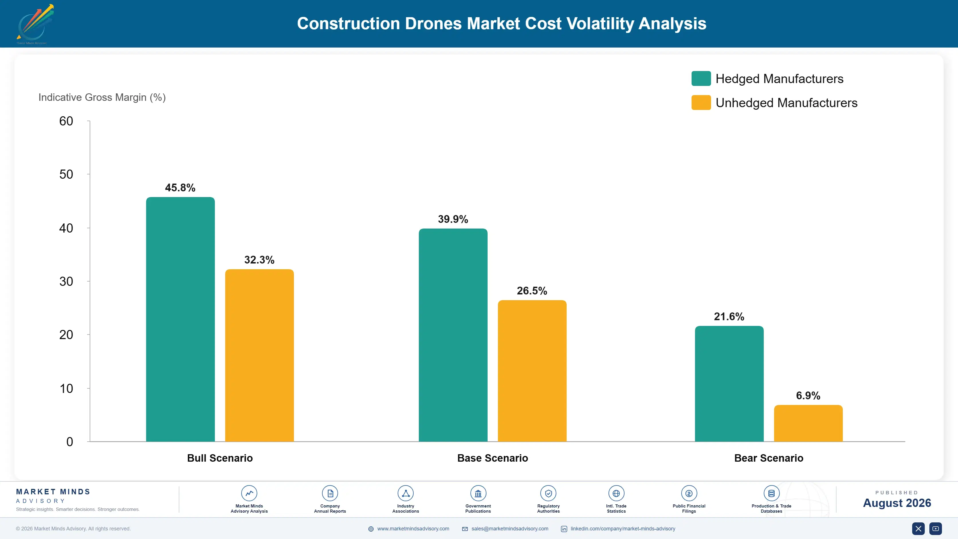
Hardware, Compute, and Data Processing Cost Pressures

Drone hardware components, cloud data processing infrastructure, and specialized imaging sensors together represent the largest cost-to-serve components for suppliers, running roughly forty to forty-five percent of total revenue, with software development and customer integration support adding a further twenty percent on top. Nearly all specialized thermal and high-resolution imaging sensors originate from a concentrated group of suppliers in the United States, Japan, and France.
Global cloud computing cost increases during 2023 pushed data processing expenses higher across software platforms handling increasingly large volumes of high-resolution flight data, a factor Trimble's 2024 Annual Report specifically cited as affecting margin across its construction technology software segment during that period. Suppliers with more efficient data processing architectures navigated this period considerably more comfortably than those relying on less optimized cloud infrastructure. Suppliers with diversified sensor sourcing recovered from this constraint more quickly than single-vendor competitors.

Smaller specialized suppliers face proportionally heavier exposure to this cost pressure because they lack the scale that DJI's broader manufacturing volume or DroneDeploy's established customer base provide through more favorable supplier and cloud computing contract terms. Specialists without comparable scale are consequently paying meaningfully higher per-unit costs, compressing margin on price-sensitive smaller construction firm contracts specifically.
construction-drones-market-cost-volatility-analysis-1787982236223

Diversify Sensor and Cloud Infrastructure Suppliers

Establishing relationships with multiple imaging sensor and cloud computing providers rather than concentrating with a single vendor reduces exposure to cost increases and capacity constraints, letting suppliers shift workloads and orders when any single vendor faces pricing pressure. Suppliers maintaining at least three active vendor relationships typically weather shortages more comfortably. This flexibility matters most during acute shortages.

Optimize Data Processing Architecture for Efficiency

Investing in more efficient data compression and processing algorithms reduces cloud computing cost per flight while maintaining image quality, a meaningful margin advantage as flight data volumes continue growing across an expanding customer base. Several smaller specialists have pursued exactly this kind of optimization successfully in recent years. This margin advantage grows meaningfully as data volumes increase over time.

Standardize Hardware Platforms Across Applications

Designing sensor and hardware platforms that work across multiple application categories rather than customizing separately for each use case reduces per-unit engineering cost and lets suppliers achieve meaningful purchasing scale faster across a broader product line. This approach also shortens overall product development timelines meaningfully across every application category. Suppliers report meaningfully faster delivery timelines as a direct result.

Portfolio Architecture for Margin Defence

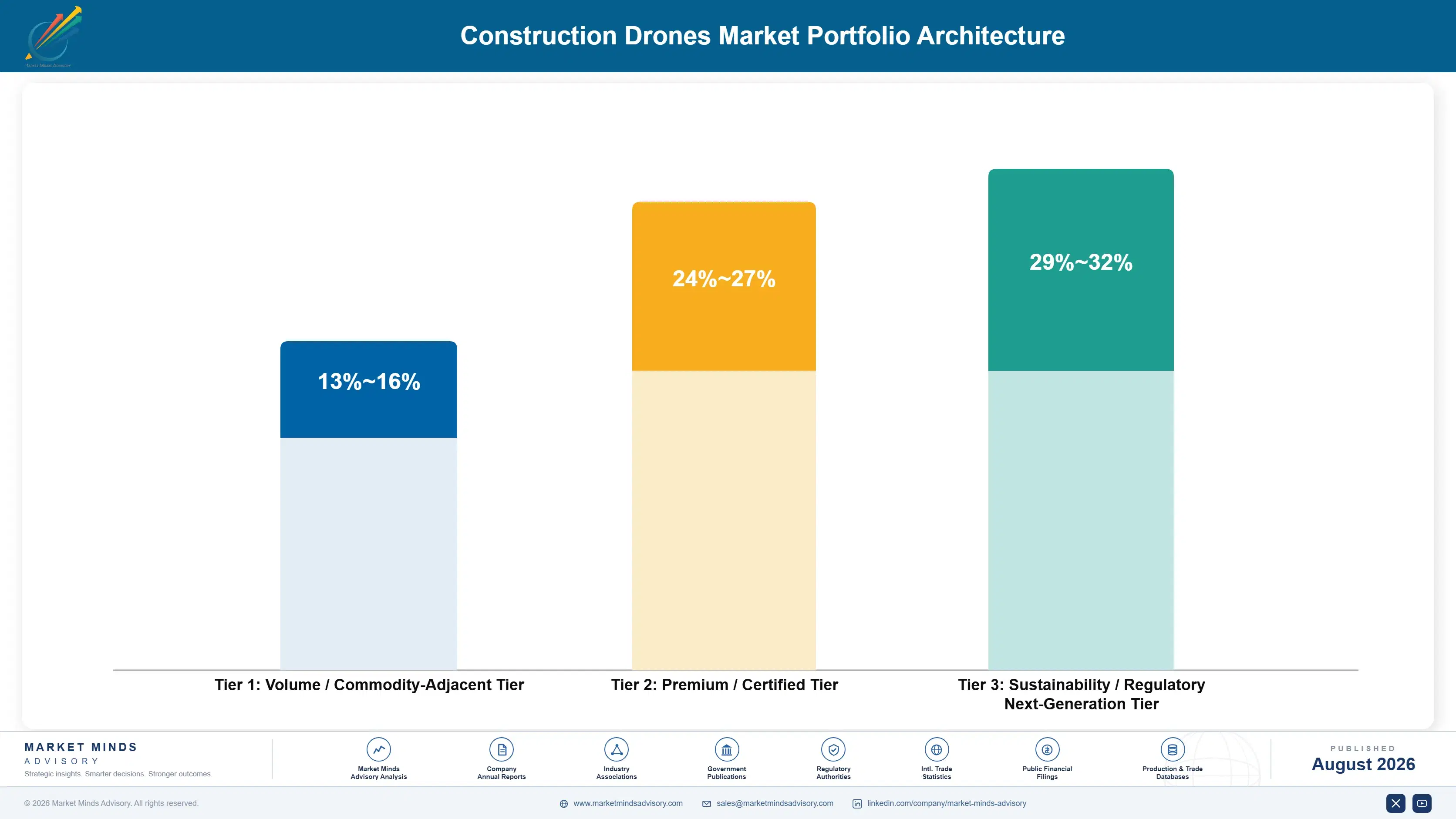
Drone suppliers architect their offering across three tiers that trade software sophistication for margin in fairly predictable steps. Basic surveying and mapping hardware anchors the volume tier at thin margin, progress monitoring and thermal auditing software occupies a premium middle tier, and structural inspection and safety monitoring platforms sit at the top as the smallest but fastest-expanding category. No single tier alone determines a supplier's overall profitability across its full product line.
The tension between volume and premium tiers reflects genuine technical difficulty rather than positioning alone: basic surveying hardware requires comparatively simple engineering and generates steady but thin-margin revenue, while structural inspection platforms require considerably deeper engineering expertise and data interpretation capability that only the most capable suppliers can deliver, which is why margin concentrates so heavily at the top of this hierarchy. This dynamic mirrors how technology companies price entry-level versus enterprise-grade offerings generally.

The highest-value pools concentrate in structural inspection platforms and building information modeling integration software, both benefiting from genuine technical barriers that smaller, less capitalized competitors cannot easily replicate without years of dedicated engineering investment. Suppliers lacking either specialty risk drifting toward the thin-margin volume tier by default.

Volume / Commodity-Adjacent Tier

Basic surveying and mapping hardware and software requiring comparatively simple engineering, sold widely across smaller construction firms with limited technology integration ambition. Most smaller construction firms operate primarily within this entry-level tier today.
Gross Margin: 13-16%

Premium / Certified Tier

Progress monitoring and thermal auditing software requiring deeper data processing and building information modeling integration expertise than basic surveying tools demand, sold mainly to larger firms. This tier attracts steady demand from larger contractors managing multiple concurrent projects.
Gross Margin: 24-27%

Sustainability / Regulatory / Next-Generation Tier

Structural inspection and safety monitoring platforms built on years of engineering and data interpretation investment that smaller, less capitalized competitors cannot quickly replicate. Only a handful of suppliers worldwide currently operate confidently within this top tier.
Gross Margin: 29-32%
construction-drones-market-portfolio-architecture-1787982236722

High-value Sub-segments and Strategic Watch-out

Structural Inspection Drones

Fastest-growing and highest-margin pool in the portfolio, driven by tightening infrastructure inspection mandates, with margin concentrated among the handful of suppliers holding proven specialized engineering capability. Suppliers here also benefit from regulation-driven demand that stays resilient during broader construction spending downturns. Growth stays strong here.
Gross Margin: 29-32%

Safety and Security Monitoring Drones

High-value segment growing steadily on insurance-driven risk reduction demand, with margin concentrated among suppliers offering genuine continuous monitoring capability over periodic manual walkthroughs. These suppliers are winning disproportionate share of demand tied directly to insurance premium incentives. Regulatory approval also moves faster given well-documented risk reduction precedent across the industry.
Gross Margin: 24-27%

Site Surveying and Mapping Drones

Largest volume core segment by installed base, serving smaller construction firms broadly, with margin staying thin due to competitive standardized pricing pressure across nearly every established supplier. Suppliers here increasingly compete on hardware cost and total cost of ownership. Pricing pressure here shows no sign of easing anytime soon.
Gross Margin: 13-16%

Building Information Modeling Integration

Strategic watch-out tied closely to native platform competition, where major construction software providers building integration in-house could compress volume for standalone specialists specifically. Native platform competition could meaningfully compress this segment's near-term growth trajectory. Suppliers dependent on standalone integration positioning face the most exposure here overall going forward.
Gross Margin: 20-23%

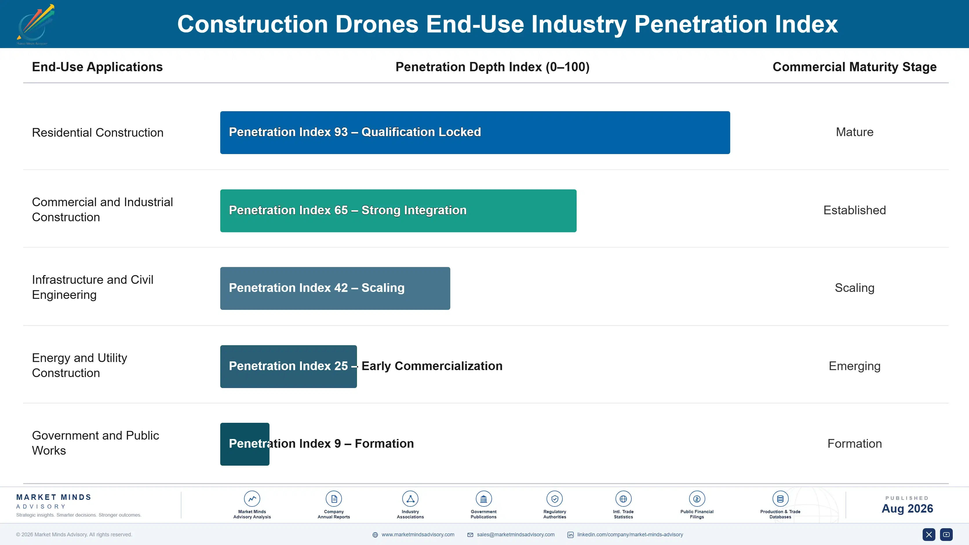
Renewal Economics and Integration Depth

Construction drone software runs on genuine annuity economics once integration depth reaches meaningful workflow embedding: subscription revenue recurs reliably as long as the platform remains connected to active project data, while hardware sales generate a smaller one-time transaction followed by periodic replacement cycles as equipment ages. This lumpiness makes revenue forecasting genuinely harder than for comparable recurring-revenue technology businesses.
Adoption depth varies sharply by vertical. Large general contractors with dedicated technology teams integrate drone data deeply into building information modeling workflows, while smaller firms remain earlier in their adoption curve, often using drones for basic aerial photography without the deeper software integration that generates the most durable customer relationships. Bridging both ends well is what separates the strongest suppliers from everyone else in this market.

A generational shift is underway as newer project managers increasingly expect drone-captured data as standard project documentation rather than an optional add-on, in contrast to veteran construction executives who historically treated site surveying as a purely manual, periodic activity rather than continuous digital capture. Suppliers slow to build credibility with this newer generation risk losing relevance over the coming decade.
construction-drones-market-end-use-penetration-index-1787982237214

Where Drone Suppliers Should Focus

These are among the four positions where our research anticipates prominent divergence between winners and laggards over the coming forecast period. Each is grounded in the demand model, the regulatory perimeter, and the announced capacity pipeline.
01 / SOFTWARE INTEGRATION PRIORITY

Deepen BIM integration ahead of native platform competition

Only thirty-one percent of projects currently integrate drone data with building information modeling software, leaving considerable room for suppliers offering deeper integration to capture disproportionate share as construction firms prioritize this over basic photography. Suppliers building genuine workflow integration can command meaningfully higher subscription pricing than standalone mapping tools. Suppliers that delay this investment, treating building information modeling as a secondary feature rather than a core platform capability, risk having their entire value proposition absorbed by native platform competitors within a few product cycles.
02 / STRUCTURAL INSPECTION FOCUS

Build specialized inspection capability for regulation-driven demand

Structural inspection drones are growing at fifteen percent annually, driven by tightening infrastructure mandates that traditional methods cannot support affordably at current staffing levels. Suppliers offering specialized imaging and thermal sensing capability can command premium pricing given the engineering expertise required to interpret inspection data for safety-critical decisions. This regulation-driven demand also proves considerably more resilient during broader construction spending downturns than discretionary applications ever manage to be, since mandated inspection work continues regardless of broader capital spending sentiment across the industry.
03 / REGULATORY STREAMLINING INVESTMENT

Establish waiver partnerships to reduce customer approval friction

Regulatory flight waivers typically take forty-five days to secure, a timeline that sits awkwardly against faster project schedules construction firms increasingly expect. Suppliers establishing pre-approved flight zone partnerships and standardized waiver templates can win contracts considerably faster than competitors requiring customers to navigate approval independently. This also reduces customer risk perception meaningfully around project timeline reliability, a genuine differentiator when construction firms compare competing supplier proposals against tight project deadlines, since predictable approval timelines matter enormously to schedules construction firms plan months in advance.
04 / API STANDARDIZATION STRATEGY

Develop standardized integration to reduce fragmented software friction

Fragmented construction software environments add roughly fifteen percent to integration cost, but suppliers offering standardized application programming interfaces can reduce this friction considerably faster than competitors requiring bespoke integration for every customer. This also shortens sales cycles meaningfully since technology teams can evaluate integration risk more confidently against a proven standardized approach. Suppliers without this capability increasingly find themselves excluded from procurement shortlists regardless of how strong their underlying data capture or analysis technology genuinely turns out to be once independently evaluated.

Engagement Snapshot From the Field

A live engagement with an industry participant carrying material or product regulatory and market exposure ahead of a defining policy shift, showing how our research translates into a defensible multi-year portfolio strategy.
MARKET MINDS ADVISORY · CLIENT ENGAGEMENT SUMMARY
Construction Drones Producer Strategic Portfolio Review and Transition Roadmap 2026·Investment Scenario on Construction Drones Exposure Evaluation 2025-26
CLIENT PROFILE
The client is a mid-sized regional general contractor managing several concurrent commercial and infrastructure projects, using drones primarily for basic aerial photography without deeper software integration. Annual revenue was approximately 410 million dollars (client-reported, unverified by MMA) at engagement start. The client sought an independent assessment of deeper building information modeling integration options. The client managed roughly a dozen concurrent projects across multiple states.
STRATEGIC CHALLENGE
The client's project managers were spending considerable time manually reviewing drone photographs to assess progress, but leadership was uncertain whether investing in deeper software integration would meaningfully improve efficiency given the client's existing fragmented technology stack across multiple project management and scheduling systems already in daily use. The board needed clarity before committing further capital investment.
MMA APPROACH
MMA benchmarked the client's existing drone workflow against comparable contractors with mature building information modeling integration, modeled time savings and cost tradeoffs across three integration platform options, and assessed technical compatibility with the client's existing project management software stack. The engagement combined this technical assessment with structured interviews across the client's project management and field operations teams.
KEY FINDINGS
  1. Manual photo review consumed roughly eight hours per project manager weekly across the client's active project portfolio (client-reported, unverified by MMA). This finding surprised several members of the leadership team.
  2. One evaluated platform offered native integration with the client's existing scheduling software, avoiding costly custom development work. This finding meaningfully simplified the client's platform selection process.
  3. Automated progress tracking would reduce manual review time by an estimated seventy percent once fully implemented. This projection assumed consistent flight data quality across all monitored project sites.
  4. Field staff required moderate additional training to capture flight data consistently enough for reliable automated analysis. Addressing this gap early prevented meaningful delays later in the rollout.
CLIENT PROFILE
The client is a mid-sized regional general contractor managing several concurrent commercial and infrastructure projects, using drones primarily for basic aerial photography without deeper software integration. Annual revenue was approximately 410 million dollars (client-reported, unverified by MMA) at engagement start. The client sought an independent assessment of deeper building information modeling integration options. The client managed roughly a dozen concurrent projects across multiple states.
STRATEGIC CHALLENGE
The client's project managers were spending considerable time manually reviewing drone photographs to assess progress, but leadership was uncertain whether investing in deeper software integration would meaningfully improve efficiency given the client's existing fragmented technology stack across multiple project management and scheduling systems already in daily use. The board needed clarity before committing further capital investment.
MMA APPROACH
MMA benchmarked the client's existing drone workflow against comparable contractors with mature building information modeling integration, modeled time savings and cost tradeoffs across three integration platform options, and assessed technical compatibility with the client's existing project management software stack. The engagement combined this technical assessment with structured interviews across the client's project management and field operations teams.
KEY FINDINGS
  1. Manual photo review consumed roughly eight hours per project manager weekly across the client's active project portfolio (client-reported, unverified by MMA). This finding surprised several members of the leadership team.
  2. One evaluated platform offered native integration with the client's existing scheduling software, avoiding costly custom development work. This finding meaningfully simplified the client's platform selection process.
  3. Automated progress tracking would reduce manual review time by an estimated seventy percent once fully implemented. This projection assumed consistent flight data quality across all monitored project sites.
  4. Field staff required moderate additional training to capture flight data consistently enough for reliable automated analysis. Addressing this gap early prevented meaningful delays later in the rollout.
RECOMMENDED STRATEGY
Phase 1: Phase 1 (Months 1 to 3): Select and implement the integration platform offering native scheduling software compatibility across all sites. Phase 2: Phase 2 (Months 4 to 8): Train field staff on consistent flight data capture protocols across all active project sites. Phase 3: Phase 3 (Months 9 to 12): Expand automated progress tracking across the client's full project portfolio, incorporating lessons learned throughout.
OUTCOME
Within twelve months, the client reduced manual photo review time meaningfully across its project portfolio and reported improved schedule visibility for project stakeholders (client-reported, unverified by MMA). The client has since become a reference customer for the selected platform's sales team. Stakeholder confidence in project timelines also improved meaningfully during the transition.

Frequently Asked Questions

Foundational context covering the market sizes, CAGR, scope, country, region and competition that inform every finding below. This section is provided to cover basics and most often pre-purchase conversations, answered from the MMA Primary Research Dataset.

What is the current size of the Construction Drones Market?

The market generated approximately 3.2 billion dollars in revenue in 2025, with adoption deepening across contractors of every size. Growth is strong, reflecting building information modeling integration and expanding inspection mandates.

How large will the Construction Drones Market be by 2036?

MMA projects the market will reach approximately 11.1 billion dollars by 2036, more than tripling revenue over the decade as growth compounds gradually with regulation and software integration.

What is the CAGR for the Construction Drones Market 2026 to 2036?

The base-case compound annual growth rate is 12.0 percent. Bull and bear scenarios range from 10.7 to 13.3 percent depending on regulatory conditions and software integration pace.

Which segment is growing fastest?

Structural inspection drones lead at a 15.0 percent CAGR, driven by tightening infrastructure mandates. Safety and security monitoring drones follow at 14.0 percent, with volumetric measurement drones growing more slowly.

Who are the major companies in the Construction Drones Market?

DJI, DroneDeploy, Skycatch, Propeller Aero, and Pix4D lead the market, together holding roughly forty-eight percent of revenue with no single company dominating both hardware and software.

Which country is growing fastest?

India leads at a 14.5 percent CAGR given its massive infrastructure investment program outpacing traditional surveying capacity. China follows closely on similar construction volume growth.

Report Segmentation Architecture

The full report scope spans multiple orthogonal segmentation dimensions, with cross-tabulated demand data provided for each dimension pair. Coverage extends further to regional breakdowns, trend trajectories, and the competitive detail needed to support segment-level decision-making.

By Primary Market Dimension

  • Site Surveying and Mapping Drones
  • Progress Monitoring and Documentation Drones
  • Structural Inspection Drones
  • Thermal and Energy Audit Drones
  • Safety and Security Monitoring Drones
  • Volumetric and Earthworks Measurement Drones

By End-Use Industry

  • Residential Construction
  • Commercial and Industrial Construction
  • Infrastructure and Civil Engineering
  • Energy and Utility Construction
  • Government and Public Works

By Commercial Dimension

  • Hardware Sales
  • Software Subscription Contracts
  • Integrated Hardware and Software Packages
  • Professional Inspection Services

By Region

  • North America
  • Western Europe
  • East Asia
  • South Asia and Pacific
  • Latin America
  • Middle East and Africa
  • Eastern Europe

Scope, Methodology, and Coverage

Every figure in this report is reproducible from documented input assumptions. The scope below maps the historical period, the forecast horizon, the segmentation dimensions, and the countries covered, alongside the underlying primary and qualitative methodology.
Historical Period
2020 to 2025
Forecast Period
2026 to 2036
Base Year
2025 (USD billions; MMA Primary Research Dataset, August 2026)
Market Definition
This report defines the Construction Drones Market as revenue from drone hardware and software platforms sold for surveying, progress monitoring, structural inspection, thermal auditing, safety monitoring, and volumetric measurement applications on construction and infrastructure project sites. It excludes general aerial photography services unrelated to construction, drone platforms sold for non-construction commercial applications, and ground-based surveying equipment.
Quantitative Units
USD billions (current prices); revenue basis
Segmentation Dimensions
By Application Function; By End-Use Industry; By Commercial Dimension; By Region
Regions Covered
North America, Western Europe, East Asia, South Asia and Pacific, Latin America, Middle East and Africa, Eastern Europe
Countries Covered
United States, China, Germany, United Kingdom, France, Japan, South Korea, India, Australia, Brazil, UAE, Saudi Arabia, Poland, and additional markets relevant to global construction technology supply
Key Companies Profiled
DJI, DroneDeploy, Skycatch, Propeller Aero, Pix4D, Trimble, Topcon Positioning, Kespry, Percepto, senseFly, Parrot, Autodesk, Bentley Systems, Hexagon AB, Sitemark, Aerodyne Group, Measure, PrecisionHawk, Cyberhawk Innovations, Botlink
Quantitative Methodology
Primary survey, n=3,800 respondents, Q4 2025, six countries; demand-side model with trade association cross-validation
Qualitative Methodology
47 expert interviews, Q4 2025; applied to validate demand model assumptions, identify emerging dynamics, and assess competitive positioning
Report Format
PDF and XLSX data workbook (Word format preview document)
Publisher
Market Minds Advisory
Report Code
MMA-2026-CON-110
Published
August 2026
Contact
sales@marketmindsadvisory.com | www.marketmindsadvisory.com

Purchase the full Construction Drones Market Report (2026 to 2036).

The full report delivers a complete quantitative and qualitative assessment of the global construction drones market, spanning ten years of forecast detail across all six application function segments. It includes company-level competitive profiling of all twenty tracked suppliers and adoption analysis of building information modeling integration across contractor size categories. Buyers also receive detailed structural inspection regulatory tracking and software platform competitive positioning not available in the summary version. A dedicated appendix walks through the primary survey and expert interview methodology underlying every forecast figure in detail. Regional benchmarking against comparable Asian and Western construction technology markets rounds out the deliverable.
Ten-year segment-level revenue forecast detail included
Full twenty-company competitive profiling and benchmarking
BIM integration adoption analysis by contractor size
Structural inspection regulatory tracking detail included
Software platform competitive positioning review included
Regulatory waiver timeline benchmarking included fully

Built For The People Who Decide

From boardroom strategy to bench-side execution, this report is read cover-to-cover by leaders shaping the next decade of their industry, turning demand scenarios, market dynamics and valuation benchmarks into decisions.
CXOs/ Presidents/ VPs/ Managers
M&A and Corporate Development
Strategy Teams and R&D Heads
Procurement and Product Directors
Regulatory and Compliance Leaders
Investor Relations and Equity Analysts